Scotter
| Scotter | |
 Scotter Green |
|
 Scotter |
|
| Population | 3,068 (2011) |
|---|---|
| OS grid reference | SE885010 |
| – London | 140 mi (230 km) S |
| District | West Lindsey |
| Shire county | Lincolnshire |
| Region | East Midlands |
| Country | England |
| Sovereign state | United Kingdom |
| Post town | GAINSBOROUGH |
| Postcode district | DN21 |
| Dialling code | 01724 |
| Police | Lincolnshire |
| Fire | Lincolnshire |
| Ambulance | East Midlands |
| EU Parliament | East Midlands |
| UK Parliament | Gainsborough |
|
|
Coordinates: 53°29′56″N 0°39′59″W / 53.498965°N 0.666311°W
Scotter is a large village and civil parish in West Lindsey, Lincolnshire, England, situated between Scunthorpe and Gainsborough.[1]
The population of the parish was recorded as 2,591 in the 2001 census,ref>"2001 Census: Key Statistics: Parish Headcounts: Area: Scotter CP (Parish)". Neighbourhood Statistics. Office for National Statistics. Retrieved 31 October 2008.</ref> increasing to 3,0658 at the 2011 census.[2] The parish church is dedicated to St Peter. It is in the Scotter with East Ferry ecclesiastical parish in the Scotton and Scotter Group of parishes, in the Manlake Deanery. Other churches in the group are Scotton and Northorpe. On the other side of Trent is the Deanery of Axholme. The village has several shops, a village hall, a community centre, and a primary school. The school has approximately 280 pupils of age range 4–11. The village hall was opened on 12 July 1985 by Birgitte, Duchess of Gloucester.
In August 2005 nine-year-old Kate Langley became the youngest girl in the world to score a hole in one, at the Forest Pines Beeches golf course on the 1st hole. The record is now held by Rhiannon Linacre.[3][4]
Geography
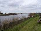
The civil parish contains the village of Susworth on the east bank of the River Trent. The parish is further north than (nearby) Kirton Lindsey. The A159 road, which connects the two towns, crosses the River Eau (a tributary of the Trent) in the village.

Barlings is at the north-west corner of the village on the River Trent, and the Lincolnshire (West Lindsey) - North Lincolnshire boundary. The county, district and parish boundary follows eastwards along the River Eau passing north of Scotterthorpe. Messingham is the parish to the north. It crosses the north-south North Moor Road which becomes Scotter Road in Scunthorpe. It crosses the north-south Messingham Road (A159) then Kirton Road (B1400). A 770 yards (700 m) section of the B1400, between Kirton and Messingham, passes through the parish, and Lincolnshire. The boundary passes southwards, touching the western edge of Black Walk Nook, a wood. It passes north-south on the edge of Black Walk Plantation and crosses two roads called Kirton Road, meeting the parish of Scotton, which is south of Scotter.
The boundary is just the parish boundary from here to the Trent. It crosses Scotter Road north of Field House, passing north of Cockthorn Farm. It skirts the north edge of a wood, and crosses the A159 near two transmitter masts. It meets East Ferry to the south and skirts the northern edge of Laughton Forest, also known as Laughton Wood. It passes westward through the western section of the wood, crossing East Ferry Road near Wheatley House. It follows Ferry Barrier Bank westwards to East Ferry Ings Drain, which it follows to the Trent near Ings Farm. It passes along the east bank of the Trent through South Ings, then passes through Susworth, passing the Jenny Wrenn Inn and Walnut Tree Farm.
References
- ↑ OS Explorer Map 280: Isle of Axholme, Scunthorpe and Gainsborough: (1:25 000) : ISBN 0 319 46432 6
- ↑ "Civil Parish population 2011". Neighbourhood Statistics. Office for National Statistics. Retrieved 29 May 2016.
- ↑ Hole in One
- ↑ Golfer
External links
 Media related to Scotter at Wikimedia Commons
- Scotter web site
- Scotter Parish Council, Lincolnshire Parish Councils
- "Scotter", Genuki
- Scotter Primary School
England Portal | |
| Unitary authorities | |
| Boroughs or districts | |
| Major settlements |
|
| Topics | |