Rongel Point


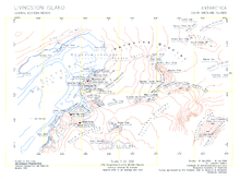
Rongel Point (Nos Rongel \'nos ron-'zhel\) is an ice-free tipped cape forming the east-northeast side of the entrance to the 710 m wide nameless cove indenting for 250 m the coast behind Rongel Reef on Livingston Island, Antarctica.
The feature takes its name from the adjacent Rongel Reef.
Location
The point is located at 62°37′03″S 60°23′57″W / 62.61750°S 60.39917°WCoordinates: 62°37′03″S 60°23′57″W / 62.61750°S 60.39917°W which is on the north-western coast of Emona Anchorage in Livingston Island in the South Shetland Islands, Antarctica, 3.14 km north-northwest of Hespérides Point, 3.68 km east-northeast of Ereby Point and 2.92 km west of Aleko Point (Bulgarian mapping from a topographic survey of the region made from 8 December 1995 to 8 February 1996; the coastal configuration in the area was altered subsequently as a result of Pimpirev Glacier's retreat in the late 20th and early 21st centuries).
Maps
- L.L. Ivanov. Livingston Island: Central-Eastern Region. Scale 1:25000 topographic map. Sofia: Antarctic Place-names Commission of Bulgaria, 1996.
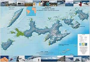
- L.L. Ivanov et al. Antarctica: Livingston Island and Greenwich Island, South Shetland Islands. Scale 1:100000 topographic map. Sofia: Antarctic Place-names Commission of Bulgaria, 2005.
References
This article includes information from the Antarctic Place-names Commission of Bulgaria which is used with permission.