Alto River
Alto River (Portuguese for High River) is a small river in the Póvoa de Varzim Municipality, whose source is located at the foot of São Félix Hill (in Laundos Parish). The river empties at Estela Parish in Rio Alto Beach. The shoreline of Estela is also known as Rio Alto.
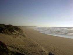
The Alto's minute estuary area is known for its wide sand dunes and has become a tourist destination. One of the local facilities is the Camping Park of Rio Alto, which is surrounded by a forest of pine trees planted by the Monks of Tibães in the 18th Century and the peculiar masseiras farm fields, which were also made by these monks.
Nearby are the Estela Golf Club, and the naturist beach area of Alto River. To the north, one can find the ruins of the Roman villa known as Villa Mendo, which was abandoned in the beginning of the early years of Portugal.
In 1908, two local individuals, knowing that ancient artifacts were sometimes found in the area, decided to investigate the place and discovered jewels, gold and silver. They decided to take the jewels to a silversmith. The silversmith, verifying the value and antiquity of the artifacts, decided to speak with Rocha Peixoto, an archaeologist who was in Póvoa de Varzim. Rocha Peixoto and José Fortes interrogated the finders on the location of the findings. Some time later, José Fortes published an article in the Portugália stating that these jewels were of the Castro culture. Several people tried to find the town that was probably below the sand dunes, but without success and only a few minor findings were discovered. Locals were known to keep silence about what they found. In June 1992, while removing sands, a bulldozer driver found a wall and ceramics, thus discovering the lost Roman villa.[1]
References
- ↑ Flores Gomes, José Manuel; Carneiro, Deolinda (2005). Subtus Montis Terroso — Património Arqueológico no Concelho da Póvoa de Varzim (in Portuguese). CMPV.
External links
- Portugal Virtual Golf Estela
- Estela Golf Club
- Orbitur Rio Alto - Camping Park

Coordinates: 41°28′N 8°47′W / 41.467°N 8.783°W