Rancho Santa Rita
Rancho Santa Rita was a 8,894-acre (35.99 km2) Mexican land grant in the western Livermore Valley, in present day Alameda County, California.
It was given in 1839 by Governor Juan Alvarado to Jose Dolores Pacheco.[1]
The rancho included present day Pleasanton, Asco, and Dougherty.[2][3][4]
History
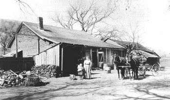
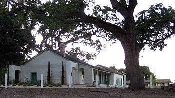
Rancho Santa Rita was granted to Pueblo de San José alcalde Jose Dolores Pacheco. It extended east from present day Foothill Road, with the Rancho Las Positas adjacent in the eastern Livermore Valley, Rancho San Ramon on the north and the Rancho Valle de San Jose on the south, Pacheco was an absentee landowner, but had a small adobe built in 1844. In 1854, Francisco Alviso, the son Pacheco's majordomo (ranch manager), Francisco Solano Alviso, built the adobe ranch house that still stands on Foothill Road overlooking Livermore Valley.
A claim for Rancho Santa Rita was filed with the Public Land Commission in 1852, and the grant was patented to John Yountz, administrator of the estate of José Dolores Pacheco in 1865.[5][6][7]
In 1853, Rancho Santa Rita was sold to Augustin Alviso, grantee of Rancho Potrero de los Cerritos, by the heirs of Jose Delores Pacheco, Juana Pacheco and Salvio Pacheco.[8] In 1854, Samuel B. Martin and West J. Martin purchased Rancho Santa Rita. They sold the ranch in 1865, and moved to Oakland.[9]
In 1865 William M. Mendenhall came to the valley, and in 1868 purchased 650 acres (2.6 km2) of the Rancho Santa Rita grant. During the period of the railroad boom in the late 1860s, Rancho Santa Rita was sub divided into fifteen farms. The farms were "small" tracts of about 300 acres (1.2 km2) to 3,750 acres (15.2 km2). The larger land owners consisted of J.W. Dougherty, 750 acres (3.0 km2); Abdijah Baker, 2,078 acres (8.4 km2); and William Knox, 360 acres (1.5 km2).
In 1869 J.W. Kottinger and J.A. Neal each laid out and plotted a subdivision for a new town called Alisal, situated about five miles south of Dublin. By 1878 the village was an unincorporated town of about 500 people, later renamed Pleasanton. Like Livermore, Pleasanton attained its size and importance with coming of the Union Pacific Railroad.
In the early 1880s, Count Valensin purchased 140 acres (0.6 km2), Maas Suders purchased a strip of land from the Mendenhall's 650 acres (2.6 km2), and Samuel Hewlett purchased 1,600 acres (6.5 km2). In 1894 the remainder of Rancho Santa Rita was offered for sale by Lagrance and Company of Oakland.
In 1921 what was left of the Mexican grant was sold to Asa Mendenhall.[10][11]
Historic sites of the Rancho
- Pacheco Adobe — the first adobe, built in 1844 by José Dolores Pacheco, is no longer standing. Its site is 0.5 miles (0.8 km) to the north of the Alviso Adobe.
- Francisco Alviso Adobe — built in 1854 by Francisco Alviso, the son of Pacheco's mayordomo (ranch manager), Francisco Solano Alviso. It is located within Alviso Adobe Community Park present day Pleasanton. [12]
See also
- Ranchos of Alameda County, California
- List of California Ranchos
References
- ↑ Ogden Hoffman, 1862, Reports of Land Cases Determined in the United States District Court for the Northern District of California, Numa Hubert, San Francisco
- ↑ Diseño del Rancho Santa Rita
- ↑ U.S. Geological Survey Geographic Names Information System: Rancho Santa Rita
- ↑ Federal Writers Project of the Works Progress Administration (5 April 2011). San Francisco in the 1930s: The WPA Guide to the City by the Bay. University of California Press. pp. 429–. ISBN 978-0-520-94887-7.
- ↑ Report of the Surveyor General 1844 - 1886
- ↑ United States. District Court (California : Northern District) Land Case 155 ND
- ↑ Yontz v. United States, 64 U.S. 23 How. 495 495 (1859)
- ↑ Mary-Jo Wainwright (2007). Pleasanton. Arcadia Publishing. pp. 31–. ISBN 978-0-7385-4761-9.
- ↑ Hoover, Mildred B.; Rensch, Hero; Rensch, Ethel; Abeloe, William N. (1966). Historic Spots in California. Stanford University Press. ISBN 978-0-8047-4482-9.
- ↑ Rancho Santa Rita (from material by Don Morton from "Historical Sites & Landmarks of Alamenda County, California", edited by George Tays. 1952)
- ↑ Mary-Jo Wainwright, 2007, Pleasanton, Arcadia Publishing, ISBN 978-0-7385-4761-9
- ↑ Francisco Solano Alviso Adobe
External links
| Wikimedia Commons has media related to Alviso Adobe. |
Coordinates: 37°40′12″N 121°52′12″W / 37.670°N 121.870°W
Municipalities and communities of Alameda County, California, United States | ||
|---|---|---|
| Cities | 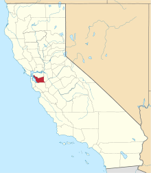 | |
| CDPs | ||
| Unincorporated communities | ||
| Former settlements | ||