Portree
| Portree | |
| Scottish Gaelic: Port Rìgh | |
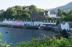 Portree Harbour |
|
 Portree |
|
| Population | 2,491 [1] |
|---|---|
| OS grid reference | NG483454 |
| Council area | Highland |
| Lieutenancy area | Ross and Cromarty |
| Country | Scotland |
| Sovereign state | United Kingdom |
| Post town | PORTREE |
| Postcode district | IV51 |
| Dialling code | 01478 |
| Police | Scottish |
| Fire | Scottish |
| Ambulance | Scottish |
| EU Parliament | Scotland |
| UK Parliament | Ross, Skye and Lochaber |
| Scottish Parliament | Skye, Lochaber & Badenoch |
| Website | www.IsleofSkye.com |
Coordinates: 57°24′43″N 6°11′22″W / 57.412070°N 6.189499°W
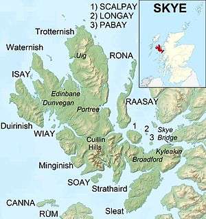
Portree (Scottish Gaelic: Port Rìgh, pronounced [pʰɔrˠʃt̪ˈtʰɾiː]) is the largest town on Skye in the Inner Hebrides of Scotland.[2] It is the location for the only secondary school on the island, Portree High School. Public transport services are limited to buses.
Portree has a harbour, fringed by cliffs, with a pier designed by Thomas Telford.[3]
Attractions in the town include the Aros centre which celebrates the island's Gaelic heritage. Further arts provision is made through arts organisation ATLAS Arts, a Creative Scotland regularly-funded organisation.[4] The town also serves as a centre for tourists exploring the island.[5]
The Royal Hotel is the site of MacNab's Inn, the last meeting place of Flora MacDonald and Bonnie Prince Charlie in 1746.[2][6]
The town plays host to the Isle of Skye's shinty club, Skye Camanachd.[7] They play at Pairc nan Laoch above the town on the road to Struan.
Around 939 people (37.72% of the population) can speak Scottish Gaelic.
The A855 road leads north out of the town, passing through villages such as Achachork, Staffin and passes the rocky landscape of the Storr before reaching the landslip of the Quiraing.
Etymology
The current name, Port Rìgh translates as 'king's port', possibly from a visit by King James V of Scotland in 1540. However this etymology has been contested, since James did not arrive in peaceful times. The older name appears to have been Port Ruighe(adh), meaning "slope harbour".[8]
Prior to the 16th century the settlement's name was Kiltaraglen ('the church of St. Talarican') from Gaelic Cill Targhlain.
Portree shale
Portree shale is a geologic association in the vicinity of Portree, the existence of which is linked with potential petroleum occurrences of commercial importance.[9]
In fiction
- 'The Portree Kid' was an amusing ballad sung by the Corries.
- Portree is the home of a fictional professional Quidditch team in the Harry Potter universe called the 'Pride of Portree'.[10]
- The film Made of Honor partially takes place in Portree. A sweeping shot of the town's main street is shown.
References
- ↑ "Census 2001". Population figures. Retrieved August 17, 2005.
- 1 2 Murray, W.H. (1966) The Hebrides. London. Heinemann. Pages 154-155.
- ↑ Portree Regeneration (15 September 2007). "Portree". Archived from the original on 17 November 2007.
- ↑ "ATLAS Arts - bringing art and audiences together in Skye and Lochalsh". Creative Scotland. Creative Scotland. Retrieved 3 January 2016.
- ↑ "Portree" Undiscovered Scotland. Retrieved on 15 September 2007.
- ↑ Haswell-Smith, Hamish. (2004) The Scottish Islands. Edinburgh. Canongate. Pages 173-4
- ↑ "Skye Camanachd" skyecamanachd.com. Retrieved 26 September 2007.
- ↑ Mac an Tàilleir, Iain (2003) Ainmean-àite/Placenames. (pdf) Pàrlamaid na h-Alba. Retrieved 26 August 2012.
- ↑ C.Michael Hogan, (2011) Sea of the Hebrides. Eds. P. Saundry & C.J.Cleveland. Encyclopedia of Earth. National Council for Science and the Environment. Washington DC.
- ↑ Whisp, Kennilworthy (2001). Quidditch Through the Ages. WhizzHard Books. pp. 31–46. ISBN 1-55192-454-4.
| Wikimedia Commons has media related to Portree. |