Ponta Cais
| Ponta do Cais | |
|---|---|
 | |
| Location | Northern Maio, Cape Verde |
| Coordinates | 15°20′17″N 23°10′48″W / 15.338°N 23.18°WCoordinates: 15°20′17″N 23°10′48″W / 15.338°N 23.18°W |
| Offshore water bodies | Atlantic Ocean |
Ponta Cais is the northernmost point of the island of Maio, Cape Verde. It is about 8 km north of the nearest village, Cascabulho.
The point also has a homonymous small lighthouse.
The island of Maio and the surrounding islands | ||
|---|---|---|
| Communities and settlements | 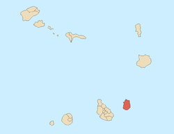 | |
| Parishes | ||
| Mountains | ||
| Other geographical features | ||
This article is issued from Wikipedia - version of the 12/5/2016. The text is available under the Creative Commons Attribution/Share Alike but additional terms may apply for the media files.