Pogledets Island
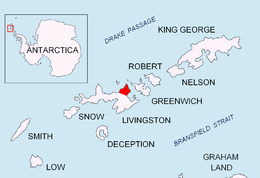 Location of Varna Peninsula on Livingston Island in the South Shetland Islands. | |
| Geography | |
|---|---|
| Location | Antarctica |
| Coordinates | 62°27′39.7″S 60°09′30″W / 62.461028°S 60.15833°W |
| Archipelago | South Shetland Islands |
| Administration | |
| Demographics | |
| Population | 0 |
| Additional information | |
| Administered under the Antarctic Treaty System | |
Pogledets Island (Bulgarian: остров Погледец, ‘Ostrov Pogledets’ \'os-trov 'po-gle-dets\) is the northernmost of Dunbar Islands off Varna Peninsula, Livingston Island in the South Shetland Islands. The feature is ice-free, crescent shaped facing southwest, and extending 200 m in north-south direction and 170 m in east-west direction. The area was visited by early 19th century sealers.
The island is named after Pogledets Peak in Rila Mountain and its namesake in Stara Planina, Bulgaria.
Location
Pogledets Island is located at 62°27′39.7″S 60°09′30″W / 62.461028°S 60.15833°W, which is 860 m northeast of Zavala Island, 450 m northwest of Aspis Island and 1.45 km southwest of Williams Point, Livingston Island. British mapping in 1968 and Bulgarian mapping in 2009.
Maps
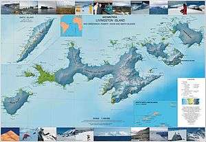
- Livingston Island to King George Island. Scale 1:200000. Admiralty Nautical Chart 1776. Taunton: UK Hydrographic Office, 1968.
- L.L. Ivanov. Antarctica: Livingston Island and Greenwich, Robert, Snow and Smith Islands. Scale 1:120000 topographic map. Troyan: Manfred Wörner Foundation, 2009. ISBN 978-954-92032-6-4 (Second edition 2010, ISBN 978-954-92032-9-5)
- Antarctic Digital Database (ADD). Scale 1:250000 topographic map of Antarctica. Scientific Committee on Antarctic Research (SCAR), 1993–2016.
References
- Bulgarian Antarctic Gazetteer. Antarctic Place-names Commission. (details in Bulgarian, basic data in English)
- Pogledets Island. SCAR Composite Antarctic Gazetteer.
This article includes information from the Antarctic Place-names Commission of Bulgaria which is used with permission.