Oberzeiring
| Oberzeiring | ||
|---|---|---|
| ||
 Oberzeiring Location within Austria | ||
| Coordinates: 47°15′00″N 14°29′00″E / 47.25000°N 14.48333°ECoordinates: 47°15′00″N 14°29′00″E / 47.25000°N 14.48333°E | ||
| Country | Austria | |
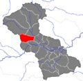
| State | Styria | |
| District | Murtal | |
| Government | ||
| • Mayor | Johann Kreuzer (ÖVP) | |
| Area | ||
| • Total | 38.23 km2 (14.76 sq mi) | |
| Elevation | 932 m (3,058 ft) | |
| Population (1 January 2016)[1] | ||
| • Total | 834 | |
| • Density | 22/km2 (57/sq mi) | |
| Time zone | CET (UTC+1) | |
| • Summer (DST) | CEST (UTC+2) | |
| Postal code | 8762 | |
| Area codes | 0 35 71 | |
| Vehicle registration | JU | |
| Website | www.oberzeiring.at | |

Oberzeiring is a former municipality in the district of Murtal in Styria, Austria. Since the 2015 Styria municipal structural reform, it is part of the municipality Pölstal.[2]
Tauern Wind Park
The Tauern Wind Park near Oberzeiring was the highest wind farm in the world at 1900m elevation when it began operating in 2002.[3] The Wind Park consists of 13 Vestas V66-1.75MW wind turbines,[3][4] and provides guided tours.[5]
Gallery

 Tauern Wind Park
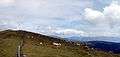 Cattle grazing before Tauern Wind Park
 Pond for snow cannons near the Tauern Wind Park
References
| Wikimedia Commons has media related to Oberzeiring. |
- ↑ Statistik Austria - Bevölkerung zu Jahresbeginn 2002-2016 nach Gemeinden (Gebietsstand 1.1.2016) for Oberzeiring.
- ↑ Die neue Gemeindestruktur der Steiermark
- 1 2 Winkelmeier, Hans; Geistlinger, Bernhard (November 2004). "Alpine Wind Harvest Report No. A/I-2/3.1./5, Work Package 03: Technological Aspects" (PDF). Friedburg. pp. 7–9. Retrieved 2008-11-23.
- ↑ "Tauernwindpark Oberzeiring: Europe's highest situated Wind Park". Retrieved 2008-11-23.
- ↑ "Tourist attraction - Adventure wind farm in the alps". Retrieved 2008-11-23.
This article is issued from Wikipedia - version of the 11/22/2016. The text is available under the Creative Commons Attribution/Share Alike but additional terms may apply for the media files.