Nicobar Islands
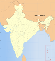
The Nicobar Islands are an archipelagic island chain in the eastern Indian Ocean and one of the most isolated in the world. They are located in Southeast Asia, 150 km north of Aceh on Sumatra, and separated from Thailand to the east by the Andaman Sea. Located 1,300 km southeast of the Indian subcontinent, across the Bay of Bengal, they form part of the Union Territory of Andaman and Nicobar Islands, India.
UNESCO has declared the islands as one of the World Network of Biosphere Reserves.[1]
Geography and population
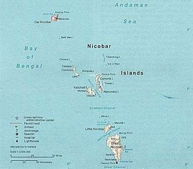
The Nicobar Islands cover a land area of 1,648.13 km2 and had a population of 36,844 at the 2011 Census. They comprise three distinct groups:
- Car Nicobar
- Battimaly
- Chowra, Chaura or Sanenyo
- Teressa or Luroo
- Bompuka or Poahat
- Katchal
- Camorta
- Nancowry or Nancowrie
- Trinket
- Laouk or "Isle of Man"
- Tillangchong
Southern Group (Sambelong):
- Great Nicobar (922 km², largest island of the Nicobars)
- Little Nicobar
- Kondul Island
- Pulo Milo or Pillomilo (Milo Island)
- Meroe, Trak, Treis, Menchal, Kabra, Pigeon and Megapod
Indira Point (6°45’10″N and 93°49’36″E) is the southernmost point of the Great Nicobar Island and India itself, about 150 km north of Sumatra, Indonesia.
Nature

The Nicobar Islands are part of a great island arc created by the collision of the Indo-Australian Plate with Eurasia. The collision lifted the Himalayas and most of the Indonesian islands, and created a long arc of highlands and islands, which includes the Arakan Yoma range of Burma, the Andaman and Nicobar islands, and the islands off the west coast of Sumatra, including the Banyak Islands and Mentawai Islands.
Ecology
The climate is warm and tropical, with temperatures ranging from 22 to 30 °C. Rainfall is heavy due to annual monsoons and measures around 3000 to 3800 mm each year. The vegetation of the Nicobars is typically divided into the coastal mangrove forests and the interior evergreen and deciduous Tropical and subtropical moist broadleaf forests. Additionally, several islands contain extensive inland grasslands, though these are thought to result from human intervention.
The Nicobar Islands are recognised as a distinct terrestrial ecoregion, the Nicobar Islands rain forests, with many endemic species.
As a result of lower sea levels during the ice ages, the Andaman Islands were linked to the Southeast Asian mainland, but it is not believed that the Nicobar Islands ever had a land bridge to the continent. Lower sea levels did link the islands to one another: Great Nicobar and Little Nicobar were linked to each other, and Nancowry, Chaura, Katchall, Trinka, Camorta, and the nearby smaller islands were linked to one another as well.
History
Prehistory
The Nicobar Islands are believed to have been inhabited for thousands of years. Six indigenous Nicobarese languages are spoken on the islands, which are part of the Mon–Khmer branch of the Austroasiatic language family, which includes Mon, Khmer and Vietnamese languages of Southeast Asia, and the Munda languages of India. An indigenous tribe living at the southern tip of Great Nicobar, called the Shompen, may be of Mesolithic Southeast Asian origin.[2]
Origin of the name
The earliest extant references to the name "Nicobar" is in the Sri Lankan Pali Buddhist chronicles, the Dipavamsa (c. 3rd or 4th century CE) and the Mahavamsa (c. 4th or 5th century), which state that the children of the followers of the legendary founder of the Sri Lankan Kingdom, Vijaya, landed on Naggadipa (the island of the children, from the Pali nagga meaning 'naked').[3] The modern name is likely derived from the Chola dynasty name for the islands, Nakkavaram or 'Puup Pii' (literally, "naked man" in Tamil) which is inscribed on the Thanjavur (Tanjore) inscription of 1050 CE.[4][5][6] Marco Polo (12th-13th century) also referred to this island as 'Necuverann'.
Colonial period
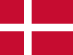
The history of organised European colonisation on the islands began with the Danish East India Company in 1754/56. During this time they were administrated from Tranquebar (in continental Danish India) administrated under the name of Frederiksøerne; missionaries from the Moravian Church Brethren's settlement in Tranquebar attempted a settlement on Nancowry and died in great numbers from disease; the islands were repeatedly abandoned due to outbreaks of malaria: 1784–1807/09, 1830–1834 and finally from 1848 gradually for good. Between 1778 and 1783, William Bolts attempted to establish an Austrian colony on the islands on the mistaken assumption that Denmark–Norway had abandoned its claims to the islands.[7]
Italy made an attempt at buying the Nicobar Islands from Denmark between 1864 and 1868. The Italian Minister of Agriculture and Commerce Luigi Torelli started a negotiation that looked promising, but failed due to the unexpected end of his Office and the first La Marmora Cabinet. The negotiations were interrupted and never brought up again.[8]
Denmark's presence in the islands ended formally on 16 October 1868 when it sold the rights to the Nicobar Islands to Britain,[7] which in 1869 made them part of British India.
World War II
During World War II, the islands were occupied by Japan between 1942 and 1945.India occupied the Island after that as its Territory.
Indian state
Together with the Andaman Islands, they became a union territory of India in 1950.
26 December 2004 tsunami
On 26 December 2004, the coast of the Nicobar Islands was devastated by a 10–15 m high tsunami following the 2004 Indian Ocean earthquake. At least 6,000 people were killed on the Andaman and Nicobar Islands with reports putting the death toll on Katchal Island alone at 4,600.
Several islands were heavily damaged with initial reports of islands broken in two or three pieces and coral reefs moved above water. Teressa Island was said to have been split into two pieces and Trinkat Island into three pieces. Some estimates said that the islands were moved as much as 100 feet (30 m) by the earthquake and tilted.
Indira Point subsided 4.25 m and the lighthouse there was damaged.
World Biosphere Reserve
On 31 May 2013 it was reported that Nicobar Islands have been declared as World Biosphere Reserve by UNESCO.[9]
Transportation
- Airport: Car Nicobar CBD/VECX has an airstrip on Car Nicobar Air Force Base of 2717 by 43 meters on the South East coast near Malacca but does not offer commercial service. Great Nicobar has a small airstrip of approximately 1000 meters at Campbell Bay/Tenlaa on its East coast.
- Seaport: At least one small shipping dock is located in Campbell Bay on the East coast of Great Nicobar. Car Nicobar has a small dock at its Northern tip near Keating Point and Mus.
- Rural communication:
See also
- Nicobarese people
- Nicobarese languages
- Shompen people
- 1881 Nicobar Islands earthquake
- Great Nicobar Biosphere Reserve
- Great Nicobar
- Malaysia Airlines Flight MH370
- Indian Ocean
References
- ↑ , The International Coordinating Council of UNESCO’s Man and the Biosphere Programme (MAB), added the following new sites to the World Network of Biosphere Reserves (WNBR) http://www.unesco.org/new/en/media-services/multimedia/photos/mab-2013/india/.
- ↑ Rajni Trivedi; et al. (March 2006). "Molecular insights into the origins of the Shompen, a declining population of the Nicobar archipelago". Journal of Human Genetics. Springer Japan. 51 (3): 217–226. doi:10.1007/s10038-005-0349-2. PMID 16453062.
- ↑ Wilhelm Geiger (Tr) (1912). The Mahavamsa or The Great Chronicle of Ceylon (PDF). Pali Text Society. ISBN 81-206-0218-8. Retrieved 8 July 2013.
P54 "The island where the children landed was called Naggadipa..." N: "l That is,'Island of children', from nagga 'naked'..."
- ↑ C Rasanayagam (1926). Ancient Jaffna. Asian Educational Society (reprint). ISBN 81-206-0210-2.
P53 "Naggadipa, where the children are alleged to have landed, is certainly Nicobars, the Nakkavaram of the Tamils, ...
- ↑ John Keay (2001). India: A History. Grove Press. ISBN 978-0-8021-3797-5.
... and 'Nakkavaram' certainly represents the Nicobar islands ...
- ↑ The New Encyclopaedia Britannica. Encyclopaedia Britannica. 1998. ISBN 978-0-85229-633-2. Retrieved 16 November 2008.
... The name Nicobar probably is derived from Nakkavaram ("Land of the Naked") ...
- 1 2 Ramerini, Marco. "Chronoly of Danish Colonial Settlements". ColonialVoyage.com. Retrieved January 2010. Check date values in:
|access-date=(help) - ↑ Ministero della Guerra, Ufficio Storico, Storia Militare della Colonia Eritrea, Vol. I, Roma 1935, pp. 15-16
- ↑ "Nicobar Islands declared as world biosphere reserve". The Times of India. 31 May 2013. Retrieved 31 May 2013.
External links
| Wikimedia Commons has media related to Nicobar Islands. |
- "Nicobarese and Shompen". The Andaman Association. Retrieved January 2010. Check date values in:
|access-date=(help) - WorldStatesmen- India
- Post-tsunami satellite photos from India's National Remote Sensing Centre (Alternate Link)
| Former colonies |
|  | ||||||
|---|---|---|---|---|---|---|---|---|
| Current overseas territories | ||||||||
Coordinates: 7°05′N 93°48′E / 7.083°N 93.800°E