Mount Albert (New Zealand)
Mount Albert (Māori: Owairaka or Te Puke-o-Ruarangi) is a volcanic peak which dominates the landscape of Mount Albert, a suburb of Auckland.
Etymology
Mount Albert was named after Queen Victoria's consort, Prince Albert, following a petition in 1866 to the Superintendent of Auckland Province, Frederick Whitaker.[1]
The common Māori name of the peak is Owairaka, which means 'Place of Wairaka'; she was the daughter of Toroa, the commander of one of the great voyaging canoes, Mātaatua.[1] An early Māori name, less commonly used, was 'Te Puke-o-Ruarangi', which literally translates as the hill of Ruarangi. He was a Māori people chief and led his people to safety from Owairaka pa on top of the peak through one of the caves lower down the hill. The members of his tribe all escaped, but Ruarangi was too large and did not fit through the hole.[1] The successful war party from the Ngāti Awa tribe were descendants from the Mātaatua canoe.[2]
Geography
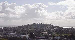
The peak, in parkland at the southern end of the suburb, is 135 metres (443 ft) in height, and is one of the many extinct cones which dot the city of Auckland, all of which are part of the Auckland volcanic field. The age of the volcano is currently unknown. The peak was formerly the site of a Māori pā, a fortified settlement. Extensive quarrying has reduced the height of the scoria cone by about 15 metres (49 ft) and significantly altered its shape, but a few remnants of Māori earthworks such as terracing are still visible.
Current uses of the cone include several playing fields, an archery club and a 31,500 cubic metres (1,110,000 cu ft) water reservoir buried in a paddock on the mountain's southern side.
References
| Wikimedia Commons has media related to Mount Albert (New Zealand). |
- 1 2 3 Reed, A. W. (2010). Peter Dowling, ed. Place Names of New Zealand. Rosedale, North Shore: Raupo. p. 255. ISBN 9780143204107.
- ↑ Reed, A. W. (1955). Auckland, the city of the seas. Wellington: A.H. & A.W. Reed. p. 23.
External links
- Photographs of Owairaka held in Auckland Libraries' heritage collections.
Coordinates: 36°53′29″S 174°43′13″E / 36.89133°S 174.72024°E