Lyutitsa Nunatak
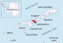

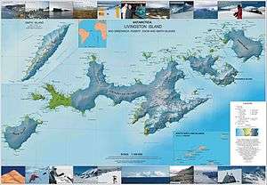
Lyutitsa Nunatak (Nunatak Lyutitsa \'nu-na-tak lyu-'ti-tsa\) is a rocky peak of elevation 430 m projecting from the ice cap in Breznik Heights on Greenwich Island, Antarctica. Overlooking Musala Glacier to the north, east, and south. Bulgarian topographic survey Tangra 2004/05.
The feature is named after the medieval fortress of Lyutitsa in the Eastern Rhodope Mountains, Bulgaria.
Location
The peak is located at 62°31′51″S 59°38′06″W / 62.53083°S 59.63500°WCoordinates: 62°31′51″S 59°38′06″W / 62.53083°S 59.63500°W which is 1.81 km west-southwest of Ilarion Ridge, 2.56 km east by north of Momchil Peak, and 1.08 km north of Vratsa Peak (Bulgarian mapping in 2009).
Maps
- L.L. Ivanov et al. Antarctica: Livingston Island and Greenwich Island, South Shetland Islands. Scale 1:100000 topographic map. Sofia: Antarctic Place-names Commission of Bulgaria, 2005.
- L.L. Ivanov. Antarctica: Livingston Island and Greenwich, Robert, Snow and Smith Islands. Scale 1:120000 topographic map. Troyan: Manfred Wörner Foundation, 2009. ISBN 978-954-92032-6-4
References
This article includes information from the Antarctic Place-names Commission of Bulgaria which is used with permission.