Loch of the Lowes
| Loch of the Lowes | |
|---|---|
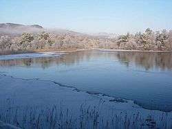 December 2005 | |
| Location | Perth and Kinross |
| Coordinates | 56°34′40″N 3°33′0″W / 56.57778°N 3.55000°WCoordinates: 56°34′40″N 3°33′0″W / 56.57778°N 3.55000°W |
| Type | loch |
| Primary inflows | Lunan Burn |
| Primary outflows | Lunan Burn |
| Catchment area | 1,400 ha (14 km2) |
| Basin countries | Scotland |
| Surface area | 88 ha (0.88 km2)[1] |
| Average depth | 7.5 m (25 ft) |
| Max. depth | 16.2 m (53 ft)[2] |
| Water volume | 5,500,000 m3 (190,000,000 cu ft)[2] |
| Surface elevation | 100 m (330 ft)[2] |
Loch of the Lowes is a loch near Dunkeld in Perth and Kinross, Scotland. The loch and the surrounding area are designated as a wildlife reserve, run by the Scottish Wildlife Trust. The loch is also a designated Site of Special Scientific Interest (SSSI), as well as forming part of a Special Area of Conservation.[3]
The loch covers 88 hectares and hosts a variety of wildlife, including a pair of breeding ospreys, red squirrels, otters and beavers.[4]
Wildfowl numbers peak in early winter when up to 3,000 migrant greylag geese roost on the loch. In addition, goldeneyes, mallards, goosanders, wigeons, teals, tufted ducks and great crested grebes can also be seen.
History
During the 19th century, a drainage canal was dug, connecting Loch of Craiglush with Lowes, causing the water levels of the two lochs to equalise. The Lunan Burn now flows through this canal. The reserve land was purchased by the Scottish Wildlife Trust in 1969, due to the loch being the largest mesotrophic loch in the area, and the presence of the rare pondweed Slender Naiad.[5]
Geography
Loch of the Lowes forms part of a chain of lochs known as the Lunan Lochs.[6] The Lunan Lochs are Lochs Craiglush, Lowes, Butterstone, Clunie and Marlee, and are connected by the Lunan Burn, which drains into the River Isla, itself a tributary of the River Tay. Loch of the Lowes, along with Loch Craiglush and Loch Butterstone, are situated just north of the Highland Boundary Fault, and are mesotrophic lochs, and are characterised by a relatively low nutrient level, as their catchment areas are mostly acidic uplands. By comparison, Lochs Clunie and Marlee are situated south of the Highland Boundary Fault, and have a higher nutrient level. The Lunan Lochs are an example of a rare habitat in the United Kingdom, which start from nutrient-poor ogliotrophic lochs further upstream; to richer, mesotrophic lochs downstream.[3]
Wildlife

Birds
The loch and surrounding woodland host a large variety of birds. In winter, pink-footed geese, greylag geese, wigeons and whooper swans can be seen on the loch, and in summer, large numbers of swallows, sand martins and swifts can be seen over the water. Tufted ducks, goldeneye and great crested grebe can be seen year-round, and both goldeneye and great crested grebe can be seen performing their courtship dance in early spring.
In the woodlands, there are jays, treecreepers, great spotted woodpeckers, siskins and sparrowhawks.[4] In the winter, redpoll and bramblings frequent the woods, and in summer, redstarts and cuckoos can be found.
Between late March to late August, there are a pair of breeding ospreys. Their nest is situated within 200 metres of an observation hide, allowing up-close viewing through binoculars, telescopes and closed-circuit television (CCTV). They can also be observed via webcam.[7]
Mammals
Fallow and roe deer are often seen from the hide and sometimes otters can be observed. Red squirrels are also quite numerous on the reserve. Recently a beaver has taken up residence on the loch.[8] The Beaver is thought to be of relation to the Tay beavers whose existence is most likely due to escapees.
Fish
Pike, perch and brown trout are all present in the loch,[2] as well as freshwater eels. It should be noted that fishing in or on the loch is not permitted at any time of year.[4]
Access
The loch is situated about 2 miles north-east of Dunkeld. A small unclassified road off the A923 leads to a small car park on the reserve.
A footpath connects the loch to Dunkeld,[9] and is suitable for walkers and cyclists, but is not suitable for wheelchair users. There is a cycle rack in the reserve car park,[10] and parking for approximately 24 cars.
Visitor Centre
The Scottish Wildlife Trust operates a visitor centre on the western side of the loch. There are observation hides offering views over the loch, and are situated close to the osprey nest. The visitor centre is one of three visitor centres operated by the Scottish Wildlife Trust, the other two being at Montrose Basin and Falls of Clyde.
References
- ↑ Loch of the Lowes Wildlife Reserve Management Plan 2011-2021, Scottish Wildlife Trust, 2011
- 1 2 3 4 Bathymetrical Survey of the Fresh-Water Lochs of Scotland 1897-1909, National Library of Scotland, 1903
- 1 2 Dunkeld - Blairgowrie Lochs, Joint Nature Conservation Committee
- 1 2 3 Loch of the Lowes - Reserve Information, Scottish Wildlife Trust
- ↑ Tayside Biodiversity Action Plan - Water - Standing Open Water, Tayside Biodiversity
- ↑ Lunan Lochs Project Natural Care Scheme (PDF), Scottish Natural Heritage
- ↑ Loch of the Lowes Osprey Webcam, Scottish Wildlife Trust
- ↑ Osprey Lady departs from Loch of the Lowes and leaves the men to it, The Courier, 2012
- ↑ Dunkeld Path Network, Perthshire Big Tree Country
- ↑ Reserve Map (PDF), Scottish Wildlife Trust, 2011