Loch of Forfar
| Loch of Forfar | |
|---|---|
| Forfar loch | |
 Loch of Forfar | |
| Location | Forfar, Angus, Scotland |
| Coordinates | 56°38′36″N 2°54′44″W / 56.64333°N 2.91222°WCoordinates: 56°38′36″N 2°54′44″W / 56.64333°N 2.91222°W[1] |
| Type | freshwater loch |
| Primary outflows | Dean Water[2] |
| Basin countries | Scotland |
| Max. length | 1 mi (1.6 km)[3] |
| Max. width | 0.14 mi (0.23 km)[3] |
| Surface area | 37.7 ha (93 acres)[1] |
| Average depth | 29 ft (8.8 m)[3] |
| Max. depth | 11.5 ft (3.5 m)[3] |
| Water volume | 51,232,000 cu ft (1,450,700 m3)[3] |
| Shore length1 | 4.3 km (2.7 mi)[1] |
| Surface elevation | 57 m (187 ft)[1] |
| Islands | 1[1] |
| 1 Shore length is not a well-defined measure. | |
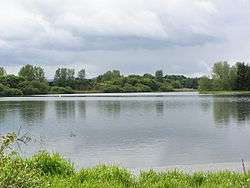
Loch of Forfar is a freshwater loch lying on the western side of the town of Forfar, Scotland. The loch trends in an east to west direction and is approximately 1 mi (1.6 km) in length. The loch and area around it form Forfar Loch Country Park.
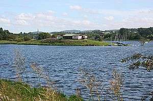
On the northern side of the loch there is a natural gravel projection which is named Queen Margaret's Inch or Saint Margaret's Inch. The projection was named after Queen Margaret, the 11th century Queen of Scots. Several historical structures have been located on the Inch including a crannog and a chapel.[4]
History
A crannog named Queen Margaret's Inch once stood on the loch. It was exposed when the loch was drained in 1781. Several items were then retrieved including silver earrings, bone chess pieces and bronze objects. It is thought that around 1243 a cell of monks from Coupar Angus Abbey inhabited the Inch and that The Chapel of the Holy Trinity and several houses were built.[5]
Recreation and leisure
The loch is a local centre for recreation and leisure activities including walking, sailing, canoeing, orienteering and fishing. The Forfar Loch Country Park Ranger Service provide a range of environmental activities and talks.[6] The Forfar Sailing Club has its facilities on the Inch.
There are several paths and trails in and around the loch all of which are marked and fully wheelchair accessible.[6]
Survey
The loch was surveyed[3] on 26 June 1903 by Sir John Murray and later charted [7] as part of Murray's Bathymetrical Survey of Fresh-Water Lochs of Scotland 1897-1909.
References
- 1 2 3 4 5 "Loch of Forfar". British lakes. British Lakes. Retrieved 3 January 2015.
- ↑ "Forfar, Loch of". Gazetteer of Scotland. Retrieved 3 January 2015.
- 1 2 3 4 5 6 "Bathymetrical Survey of the Fresh-Water Lochs of Scotland, 1897-1909, Lochs of the Tay Basin". National Library of Scotland. Retrieved 3 January 2015.
- ↑ "Forfar Loch, St Margaret's Inch". Canmore. Retrieved 4 January 2015.
- ↑ "Forfar Loch, St Margaret's Inch". Canmore. Retrieved 4 January 2015.
- 1 2 "Forfar Loch Country Park". Angus Council. Retrieved 3 January 2015.
- ↑ "Loch Benachally; Loch of Lintrathen; Loch Shechernich; Auchenchapel Loch; Loch o.. - Bathymetrical Survey, 1897-1909 - National Library of Scotland". National Library of Scotland. Retrieved 3 January 2015.