Loch Stack
| Loch Stack | |
|---|---|
 Loch Stack | |
| Location | Sutherland, Scotland |
| Coordinates | 58°20′12″N 4°55′28″W / 58.336700°N 4.924500°W[1] |
| Type | freshwater loch |
| Primary inflows | An Earachd[2] |
| Primary outflows | River Laxford [2] |
| Basin countries | Scotland |
| Max. length | 2.5 mi (4.0 km)[2] |
| Surface area | 252.1 ha (623 acres)[1] |
| Average depth | 86 ft (26 m)[2] |
| Max. depth | 108 ft (33 m)[2] |
| Water volume | 988,000,000 cu ft (28,000,000 m3)[2] |
| Shore length1 | 16.6 km (10.3 mi)[1] |
| Surface elevation | 46 m (151 ft)[1] |
| Islands | 1[1] |
| 1 Shore length is not a well-defined measure. | |
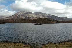
Loch Stack is a large, irregular shaped freshwater loch in the Northwest of Scotland. It lies approximately 4 mi (6.4 km) southeast of Laxford Bridge and is surrounded by mountains. Ben Stack rises steeply from the loch's southwestern shore and Arkle lies directly to the north.
Survey
The loch was surveyed[2] between the 6 and 8 September 1902 by T.N. Johnston and James Murray and later charted [3] as part of the Sir John Murray's Bathymetrical Survey of Fresh-Water Lochs of Scotland 1897-1909.
References
- 1 2 3 4 5 "Loch Stack". British lakes. British Lakes. Retrieved 6 May 2015.
- 1 2 3 4 5 6 7 "Bathymetrical Survey of the Fresh-Water Lochs of Scotland, 1897-1909, Lochs of the Laxford Basin". National Library of Scotland. Retrieved 6 May 2015.
- ↑ "Loch Stack (Laxford Basin) (Vol. 5, Plate 9) - Bathymetrical Survey, 1897-1909 - National Library of Scotland". National Library of Scotland. Retrieved 6 May 2015.
This article is issued from Wikipedia - version of the 5/6/2015. The text is available under the Creative Commons Attribution/Share Alike but additional terms may apply for the media files.