Loch Scaven
| Loch Scaven | |
|---|---|
| Loch Sgamhain | |
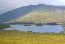 Loch Scaven looking west | |
| Location | Wester Ross, Scotland |
| Coordinates | 57°31′31″N 5°10′35″W / 57.52528°N 5.17639°WCoordinates: 57°31′31″N 5°10′35″W / 57.52528°N 5.17639°W |
| Type | freshwater loch |
| Primary inflows | River Carron |
| Primary outflows | River Carron |
| Basin countries | Scotland |
| Max. length | 1 mi (1.6 km)[1] |
| Max. width | 0.33 mi (0.53 km)[1] |
| Surface area | 58.7 ha (145 acres)[2] |
| Average depth | 27 ft (8.2 m)[1] |
| Max. depth | 72 ft (22 m)[1] |
| Water volume | 165,000,000 cu ft (4,700,000 m3)[1] |
| Shore length1 | 4.6 km (2.9 mi)[2] |
| Surface elevation | 152 m (499 ft)[2] |
| Islands | 2 islets |
| 1 Shore length is not a well-defined measure. | |
Loch Scaven (Gaelic: Loch Sgamhain) is a small freshwater loch at the head of Glen Carron near the source of the River Carron, Wester Ross, Scotland. It is about 4 mi (6.4 km) southwest of Achnasheen and 2 mi (3.2 km) from Loch Gowan. The loch tends in a northeast to southwest direction and its shore is relatively simple. At the west end there is a significant promontory known as 'Cnoc nan Sguad' which projects into the loch on the northern shore. There are two small islands in the centre of the loch opposite Cnoc nan Sguad.
The loch was surveyed on 8 August 1902[1] by R.M. Clark and James Murray and later charted[3] as part of the Sir John Murray and Laurence Pullar's Bathymetrical Survey of Fresh-Water Lochs of Scotland 1897-1909.
References
- 1 2 3 4 5 6 Sir John Murray (1910). "Bathymetrical Survey of the Fresh-Water Lochs of Scotland, 1897-1909, Lochs of Loch Carron basic". www.nls.uk. Retrieved 2014-12-22.
- 1 2 3 "Loch Sgamhainr". www.britishlakes.info. Retrieved 2014-12-22.
- ↑ "Loch Sgamhain (Vol. 5, Plate 21)". www.nls.uk. Retrieved 23 December 2014.
This article is issued from Wikipedia - version of the 1/23/2016. The text is available under the Creative Commons Attribution/Share Alike but additional terms may apply for the media files.