Loch Bràigh Horrisdale
| Loch Bràigh Horrisdale | |
|---|---|
| Loch Horrisdale | |
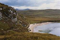 The eastern shore of Loch Braigh Horrisdale | |
| Location | Gairloch, Wester Ross, Scotland |
| Coordinates | 57°40′9″N 5°41′41″W / 57.66917°N 5.69472°WCoordinates: 57°40′9″N 5°41′41″W / 57.66917°N 5.69472°W[1] |
| Type | freshwater loch[2] |
| Primary inflows | streams from Loch a' Bhealaich and Loch a' Ghobhainn[2] |
| Primary outflows | Badachro River[3] |
| Basin countries | Scotland |
| Max. length | 0.75 mi (1.21 km)[2] |
| Max. width | 0.33 mi (0.53 km)[2] |
| Surface area | 38.2 ha (94 acres)[1] |
| Average depth | 18 ft (5.5 m)[2] |
| Max. depth | 51 ft (16 m)[2] |
| Water volume | 62,000,000 cu ft (1,800,000 m3)[2] |
| Shore length1 | 3.7 km (3.7 km)[1] |
| Surface elevation | 92 m (302 ft)[1] |
| 1 Shore length is not a well-defined measure. | |
Loch Bràigh Horrisdale is a small, irregular shaped, freshwater loch in Wester Ross, in the north west of Scotland. The loch lies approximately 2 mi (3.2 km) south southeast of the village of Badachro and is close to the Fairy Lochs.
An in-river hydro-electric scheme down-stream of the loch has been proposed. As a result of this, an environmental assessment of the fish and fish habitat of the loch and its outflow was commissioned. The assessment was reported in 2014. A full EIA planning application for the 2MW scheme was lodged with Highland Council by Three Lochs Hydro Ltd on 28 July 2016.[4]
The loch was surveyed on 6 August 1902[2] by T.N. Johnston and John Hewitt and later charted[5] as part of the Sir John Murray's Bathymetrical Survey of Fresh-Water Lochs of Scotland 1897-1909.
References
- 1 2 3 4 "Loch Braigh Horrisdale". British lakes. British Lakes. Retrieved 3 January 2015.
- 1 2 3 4 5 6 7 8 "Bathymetrical Survey of the Fresh-Water Lochs of Scotland, 1897-1909, Lochs of the Gairloch basin". National Library of Scotland. Retrieved 16 November 2014.
- ↑ "Sheet 25 - Raasay & Applecross". National Library of Scotland. Retrieved 16 November 2014.
- ↑ "EIA application for installation of 2MW hydro-electric scheme, including erection of powerhouse and intake structure, upgrading and formation of access tracks and bridges". The Highland Council. Retrieved 15 August 2016.
- ↑ "Loch an Eilein; Loch Bad a' Chrotha; Loch Braigh Horrisdale; Loch Bad an Sgalaig...". National Library of Scotland. Retrieved 16 November 2014.