List of Local Nature Reserves in Buckinghamshire
Buckinghamshire is a county in south-east England.[1] Its county town is Aylesbury,[2] and it is surrounded by Northamptonshire to the north, Bedfordshire, Hertfordshire and Greater London to the east, Surrey and Berkshire to the south, and Oxfordshire to the west.[3] Under Buckinghamshire County Council there are four districts, Aylesbury Vale, Chiltern, South Bucks and Wycombe, while Milton Keynes has a separate unitary borough council.[4] Buckinghamshire has an area of 1874 km², and a population of 739,600.[5]
Local Nature Reserves (LNRs) are designated by local authorities under the National Parks and Access to the Countryside Act 1949. The local authority must have a legal control over the site, by owning or leasing it or having an agreement with the owner. LNRs are sites which have a special local interest either biologically or geologically, and local authorities have a duty to care for them. They can apply local bye-laws to manage and protect LNRs.[6][7]
As of July 2016 there are sixteen LNRs in Buckinghamshire.[8][lower-alpha 1] Four are in Aylesbury Vale, one each in Chiltern and Milton Keynes, three in South Bucks and seven in Wycombe. Two sites are also Sites of Special Scientific Interest and four are in the Chilterns Area of Outstanding Natural Beauty. The largest is Black Park LNR with 65.8 hectares. This is part of the 250 hectare Black Park Country Park and the forty-three square mile Colne Valley regional park.[13] The smallest site is the 0.5 hectare Coombs Quarry, which has geological interest due to a Jurassic layer, and Romano-British archaeology.[14] There is public access to all sites except Buckingham Sand Pit.
Key
Other classifications
- BBOWT = Berkshire, Buckinghamshire and Oxfordshire Wildlife Trust
- CAONB = Chilterns Area of Outstanding Natural Beauty
- CVRP = Colne Valley regional park
- NT = National Trust
- SM = Scheduled Monument
- SSSI = Site of Special Scientific Interest
Sites
| Site | Photograph | Area[lower-alpha 2] | Location[lower-alpha 3] | Borough | Other classifications | Map[lower-alpha 4] | Details[lower-alpha 5] | Description |
|---|---|---|---|---|---|---|---|---|
| Bacombe Hill | 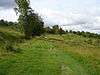 |
24.6 hectares (61 acres) | Upper Bacombe 51°45′22″N 0°45′25″W / 51.756°N 0.7569°W SP859071 |
Aylesbury Vale | BBOWT,[16] CAONB,[17] NT,[18] SSSI[19] | Map | Details | The hill is chalk grassland which has a rich variety of species. including the entire British population of fringed gentian, and there are areas of juniper and mixed scrub. Invertebrates include scarce species, such as chalkhill blue and brown argus butterflies.[19] The site is also noted for its orchids.[20] |
| Black Park | 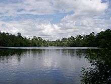 |
65.8 hectares (163 acres) | Wexham 51°32′45″N 0°32′42″W / 51.545866°N 0.54487446°W TQ010840 |
South Bucks | CVRP,[13] SSSI[13] | Map | Details | This site has heath and alder carr, both of which are rare in the county. There is also mixed and coniferous woodland, and some areas of acid grassland. The fauna is diverse, and insects include the nationally rare Roesel's bush cricket. There are eighteen species of butterfly, birds including hobbies and nightjars, and snakes and lizards.[13] |
| Blue Lagoon | 33.1 hectares (82 acres) | Milton Keynes 51°59′06″N 0°44′15″W / 51.985°N 0.7375°W SP868326 |
Milton Keynes | Map | Details | The lake is 18 metres deep with clean water and diverse wildlife. Spoil heaps around the lake have been naturally colonised to become grassland, scrub and woodland. The grassland has fauna and flora typical of chalk downland.[21] | ||
| Brush Hill |  |
14.7 hectares (36 acres) | Princes Risborough 51°43′27″N 0°48′51″W / 51.7242°N 0.8142°W SP820035 |
Wycombe | CAONB[22] | Map | Details | Habitats on the site are chalk grassland, woodland and scrub. Flora include wood anemone and wood sorrel, and there are birds such as nuthatches and treecreepers.[23] At the top of the hill there is ancient woodland with oak, Scots pine and larch. The grassland is grazed by sheep between October and March.[24] |
| Buckingham Sand Pit | 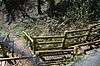 |
1.8 hectares (4.4 acres) | Buckingham 52°00′13″N 0°58′59″W / 52.003647°N 0.98314473°W SP699344 |
Aylesbury Vale | Map | Details | The site is important geologically as it is a rare exposure of Quaternary Ice Age layers, showing clays, sands and pebble layers from the Anglian Ice Age around 450,000 years ago, when Buckingham was under two kilometres of ice. There is also evidence for the tundra phase which followed. There is no public access to the site.[25] | |
| Captain's Wood | 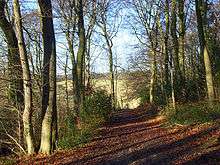 |
13.9 hectares (34 acres) | Chesham 51°43′17″N 0°37′34″W / 51.7213°N 0.6261°W SP950034 |
Chiltern | CAONB[26] | Map | Details | The Chiltern Society took over management of this site from Buckinghamshire County Council in 2014.[26] It is described by the Society as ancient beech woodland which has high ecological value. In spring it is carpeted with bluebells.[27] |
| Chairborough Road | 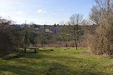 |
3.9 hectares (9.6 acres) | High Wycombe 51°37′26″N 0°46′35″W / 51.6240°N 0.7764°W SU848924 |
Wycombe | Map | Details | The site has diverse habitats, with chalk grassland, woodland and scrub, and it has a wide variety of plant and animal species. There are birds such as bullfinches, and mammals include muntjac deer, foxes and badgers. Slow-worms and lizards bask in the summer on bare ground or on anthills.[28] | |
| Coombs Quarry | 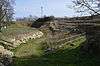 |
0.5 hectares (1.2 acres) | Buckingham 51°59′15″N 0°56′02″W / 51.9876°N 0.9339°W SP733326 |
Aylesbury Vale | Map | Details | This very small site has geological, botanical and archaeological interest. It was disused for almost a century before being opened to the public in 1993. It had lime kilns in the Roman period, and was used for quarrying building stone and rock for lime burning until the end of the nineteenth century. It exposes Jurassic Blisworth Clay, probably laid down in shallow brackish water.[14] | |
| Gomm's Wood | 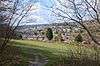 |
18.1 hectares (45 acres) | High Wycombe 51°38′03″N 0°42′30″W / 51.6341°N 0.70822°W SU895936 |
Wycombe | Map | Details | The site has areas of chalk grassland and ancient woodland. The woods have a range of birds such as bullfinches and chaffinches. The grassland has a variety of orchids, and insects include bees and butterflies.[29] | |
| Holtspur Bank | 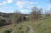 |
6.6 hectares (16 acres) | Beaconsfield 51°36′11″N 0°40′33″W / 51.603167°N 0.67588927°W SU918902 |
South Bucks | Map | Details | Half of the site is chalk grassland and half ancient woodland. It has a wide variety of species including many orchids on the grassland, and oaks with some cherry trees in the woodland. The understorey has holly, elderberry, hawthorn and honeysuckle. It is one of only two sites in South Buckinghamshire where dormice have been recorded.[30][31] | |
| Northmoor Hill Wood | 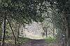 |
8.7 hectares (21 acres) | Denham 51°35′32″N 0°30′32″W / 51.5921°N 0.50875°W TQ 034 892 |
South Bucks | Map | Details | The western area has wet clay flora, with alder woodland, sedges, rushes, yellow archangel and star of Bethlehem orchids.[32] Geologically, the western end is in the Reading Formation, dating to the Tertiary period. The eastern part is chalk, and an old chalk quarry exposes layers dating to the Cretaceous period.[33] | |
| Prestwood (Picnic Site) | 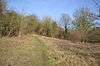 |
2.1 hectares (5.2 acres) | Prestwood 51°41′02″N 0°44′56″W / 51.6840°N 0.74875°W SU866991 |
Chiltern | CAONB[34] | Map | Details | This is steeply sloping chalk grassland with a diverse range of species, including some rare ones. Birds include bullfinches, blackcaps and garden warblers, and there are butterflies such as dingy and grizzled skippers and green hairstreaks.[35] |
| Sands Bank |  |
11.1 hectares (27 acres) | High Wycombe 51°38′00″N 0°47′47″W / 51.633238°N 0.79638658°W SU834934 |
Wycombe | Map | Details | The site is a mixture of woodland, scrub and grassland on a south facing chalk slope. Some of the beech woodland dates back 400 years, and there is younger cherry, holly, yew and ash. Ground plants include wood spurge and goldilocks buttercup, and there are mammals such as roe deer and hazel dormice. There is a wide variety of fungi.[36] | |
| Snakemoor | 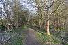 |
1.8 hectares (4.4 acres) | Haddenham 51°46′17″N 0°56′47″W / 51.7713°N 0.94634°W SP728086 |
Aylesbury Vale | Map | Details | The site became a nature reserve in 1987. It has a hay meadow, woods and a pond. There are over 100 species of flowers and other plants, including snowdrops and lent lily, a small native species of daffodil.[37][38] | |
| Warren Nature Reserve | 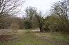 |
2.3 hectares (5.7 acres) | Wooburn 51°35′01″N 0°41′01″W / 51.5835°N 0.68368°W SU913880 |
Wycombe | Map | Details | The River Wye runs along the north-west border of the site, providing a habitat for birds such as mallards, herons and kingfishers. The reserve is wooded with a variety of trees such as ash, lime and oak. Animals include badgers, voles, grass snakes, muntjac deer and bats.[39] | |
| Whiteleaf Hill | 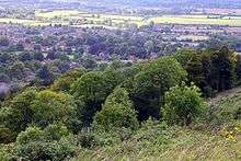 |
11.0 hectares (27 acres) | Princes Risborough 51°43′40″N 0°48′41″W / 51.7278°N 0.81125°W SP822039 |
Wycombe | CAONB,[40] SM[41] | Map | Details | The southern half of the site is semi-natural beech woodland which dates back to at least 1600. Most of the mature trees were lost during storms in the late twentieth century, but they have been replaced by scrub which is regenerating into forest. Birds include whitethroats, and there are butterflies such as the speckled wood and the peacock.[42] |
See also
| Wikimedia Commons has media related to Local Nature Reserves in Buckinghamshire. |
- List of Sites of Special Scientific Interest in Buckinghamshire
- List of Local Nature Reserves in England
- Berkshire, Buckinghamshire and Oxfordshire Wildlife Trust
Notes
- ↑ Natural England lists a seventeenth Buckinghamshire LNR, Denham Quarry Park, but this appears to be an error. The River Colne forms the boundary between Buckinghamshire to the west and the London Borough of Hillingdon to the east. The Natural England map shows most of Denham Quarry Park east of the river in Hillingdon, in an area which is also designated a London LNR, Denham Country Park.[9][10][11][12]
- ↑ The area is taken from the Natural England map of each site. (Click on the identify icon (i) in the "Feature Tools" and then click on the site.)[15]
- ↑ The location is taken from the Natural England details page for the site.
- ↑ The maps are on the Natural England database of Local Nature Reserves.
- ↑ Details are on the pages on each site in the Natural England database of Local Nature Reserves.[15]
References
- ↑ "South East (England)". Office for National Statistics. Retrieved 19 April 2016.
- ↑ "Aylesbury". Visit Buckinghamshire. Retrieved 19 April 2016.
- ↑ The Ordnance Survey Atlas of Great Britain. London, UK: Book Club Associates. 1982. p. 189.
- ↑ "Your Guide to the Counties of England". Counties in England. Retrieved 9 December 2015.
- ↑ "Buckinghamshire Quick Facts & Figures". Essential Travel Guide. Retrieved 19 April 2016.
- ↑ "Protected or designated areas". Department for Environment, Food & Rural Affairs and Natural England. 9 April 2013. Retrieved 29 July 2015.
- ↑ "Local nature reserves: setting up and management". Department for Environment, Food & Rural Affairs and Natural England. 2 October 2014. Retrieved 29 July 2015.
- ↑ "Local Nature Reserves: Search Results for Buckinghamshire". Natural England. Retrieved 3 July 2016.
- ↑ "Denham Quarry Park". Local Nature Reserves. Natural England. 8 June 2015. Retrieved 7 April 2016.
- ↑ "Map of Denham Quarry Park". Local Nature Reserves. Natural England. Retrieved 7 April 2016.
- ↑ "Denham Country Park". Local Nature Reserves. Natural England. 23 March 2015. Retrieved 7 April 2016.
- ↑ "Map of Denham Country Park". Local Nature Reserves. Natural England. Retrieved 7 April 2016.
- 1 2 3 4 "Black Park citation" (PDF). Sites of Special Scientific Interest. Natural England. Retrieved 30 December 2014.
- 1 2 "Coombs Quarry". Bucks Earth Heritage Group. Retrieved 8 April 2016.
- 1 2 "Local Nature Reserves: Search Results for Buckinghamshire". Natural England. Retrieved 30 September 2015.
- ↑ "Bacombe Hill". Berkshire, Buckinghamshire and Oxfordshire Wildlife Trust. Retrieved 30 June 2016.
- ↑ "Bacombe Hill Local Nature Reserve". Chilterns Conservation Board. Retrieved 4 January 2015.
- ↑ "Chilterns Countryside". National Trust. Retrieved 28 September 2015.
- 1 2 "Bacombe and Coombe Hills citation" (PDF). Sites of Special Scientific Interest. Natural England. Retrieved 4 January 2015.
- ↑ "Bacombe Hill". Local Nature Reserves. Natural England. 8 August 2013. Retrieved 4 January 2015.
- ↑ "Blue Lagoon". Local Nature Reserves. Natural England. 4 June 2015. Retrieved 26 October 2015.
- ↑ "Brush Hill Wildlife Walks". Chilterns Conservation Board. Retrieved 27 October 2015.
- ↑ "Brush Hill". Local Nature Reserves. Natural England. 8 June 2015. Retrieved 27 October 2015.
- ↑ "Brush Hill Wildlife". Chiltern Society. Retrieved 27 October 2015.
- ↑ "Buckingham Sand Pit". Bucks Earth Heritage Group. Retrieved 7 April 2016.
- 1 2 "Chiltern Society takes on 5 new sites". Chilterns Conservation Board. 23 October 2014. Retrieved 6 April 2016.
- ↑ "Six Special Places". Chiltern Society. 23 October 2014. Retrieved 6 April 2016.
- ↑ "Chairborough Road". Local Nature Reserves. Natural England. 8 August 2013. Retrieved 19 February 2016.
- ↑ "Gomm's Wood". Local Nature Reserves. Natural England. 8 June 2015. Retrieved 18 July 2016.
- ↑ "Holtspur Bank Local Nature Reserve". Beaconsfield Town Council. Retrieved 8 April 2016.
- ↑ "Flora". Friends of Holtspur Bank Nature Reserve. Retrieved 8 April 2016.
- ↑ "Northmoor Hill Wood". Local Nature Reserves. Natural England. 23 August 2013. Retrieved 13 March 2016.
- ↑ "Northmoor Hill". Bucks Earth Heritage Group. Retrieved 13 March 2016.
- ↑ "Visiting Prestwood LNR". Chiltern Society. Retrieved 19 February 2016.
- ↑ "Prestwood (Picnic Site)". Local Nature Reserves. Natural England. 8 June 2015. Retrieved 19 February 2016.
- ↑ "Sands Bank Local Nature Reserve" (PDF). Chiltern Rangers. Archived from the original (PDF) on 16 February 2016. Retrieved 18 July 2016.
- ↑ "Snakemoor". Local Nature Reserves. Natural England. 23 August 2013. Retrieved 26 March 2016.
- ↑ "About Snakemoor". Haddenham Parish Council. Retrieved 26 March 2016.
- ↑ "Warren Nature Reserve". Local Nature Reserves. Natural England. 8 June 2015. Retrieved 29 February 2016.
- ↑ "Whiteleaf Hill and Whiteleaf Cross". Chilterns Conservation Board. Retrieved 29 October 2015.
- ↑ "The History of Whiteleaf" (PDF). Buckinghamshire County Council. Retrieved 29 October 2015.
- ↑ "Wildlife" (PDF). Buckinghamshire County Council. Retrieved 29 October 2015.
Coordinates: 51°50′N 0°50′W / 51.833°N 0.833°W