Futalaufquen Lake
| Futalaufquen Lake | |
|---|---|
 | |
| Location | Futaleufú Department, Chubut Province |
| Coordinates | 42°49′S 71°43′W / 42.817°S 71.717°WCoordinates: 42°49′S 71°43′W / 42.817°S 71.717°W |
| Catchment area | 2920 km² |
| Basin countries | Argentina |
| Surface area | 44 km² |
| Average depth | 101 m |
| Max. depth | 168 m |
| Water volume | 4.51 billion km³ |
| Shore length1 | 72.5 km |
| 1 Shore length is not a well-defined measure. | |
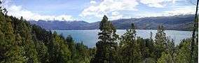
Futalaufquen Lake is located in the Argentine province of Chubut. This name came from the Mapudungun language. "Futa" means great, and "laufquen" means lake.
Location
Lake Futalaufquen is located within the national park Los Alerces. It originates from a glacier, and is in a deep valley, the ancient remains of a large glacier that was there 10,000 years behind the end of the last ice age.
Description
The surface lies at an altitude of 518 meters with an area of 44,600,000 square meters (44.6 square km). The average depth is 101 meters and the greatest depth is 168 meters. The length of its shores is 72.5 km. The area of the water basin is 2,920 km2. The volume of water contained in the lake is 4.51 billion km3 or metric tonnes.
It lets 150m3 of water into the Río Futaleufú each second.
Water is present 94% of the year.
Outlet
It leaves the basin by means of the Río Futaleufú, from which the water crosses the mountains to empty into the Pacific Ocean in Chile.
Sources
- Translated from the French version of this page.