Kokalyane Point

Location of Rugged Island in the South Shetland Islands.
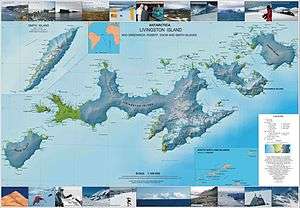
Topographic map of Livingston Island, Greenwich, Robert, Snow and Smith Islands.
Kokalyane Point (Bulgarian: нос Кокаляне, ‘Nos Kokalyane’ \'nos ko-'ka-lya-ne\) is the point on the west coast of Rugged Island in the South Shetland Islands, Antarctica forming the south side of the entrance to Bogomil Cove. Situated 810 m north-northwest of Benson Point, 970 m south of Ugain Point and 2.51 km south of Cape Sheffield.
The point is named after the settlement of Kokalyane in western Bulgaria.
Location
Kokalyane Point is located at 62°38′10.9″S 61°17′47″W / 62.636361°S 61.29639°WCoordinates: 62°38′10.9″S 61°17′47″W / 62.636361°S 61.29639°W, according to Spanish mapping in 1992 and Bulgarian mapping in 2009.
Maps
- Península Byers, Isla Livingston. Mapa topográfico a escala 1:25000. Madrid: Servicio Geográfico del Ejército, 1992.
- L.L. Ivanov. Antarctica: Livingston Island and Greenwich, Robert, Snow and Smith Islands. Scale 1:120000 topographic map. Troyan: Manfred Wörner Foundation, 2009. ISBN 978-954-92032-6-4
References
This article includes information from the Antarctic Place-names Commission of Bulgaria which is used with permission.
This article is issued from Wikipedia - version of the 11/22/2015. The text is available under the Creative Commons Attribution/Share Alike but additional terms may apply for the media files.