Kirigalpotta
| Kirigalpotta | |
|---|---|
|
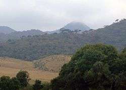
The mountain as seen from the entrance of the Horton Plains National Park. | |
| Highest point | |
| Elevation | 2,388 m (7,835 ft) |
| Coordinates | 06°47′57″N 80°46′00″E / 6.79917°N 80.76667°ECoordinates: 06°47′57″N 80°46′00″E / 6.79917°N 80.76667°E |
| Geography | |
 Kirigalpotta | |
Kirigalpotta is the 2nd tallest mountain in Sri Lanka at 2,388 m (7,835 ft) above mean sea level, and is also the highest mountain in the country whose summit is accessible to the general public (the highest point, Pidurutalagala, is occupied by a military base and off-limits to the public). The peak is situated near the city of Nuwara Eliya, within the Nuwara Eliya District.[1][2] Only one 7 km (4 mi) hiking trail provides access to the mountain's summit via the Horton Plains National Park, although the trail is not very popular.
See also
References
| Wikimedia Commons has media related to Kirigalpotta. |
- ↑ "Highest mountains in Sri Lanka". Archived from the original on December 6, 2008. Retrieved 2010-04-19.
- ↑ "Mount Kirigalpotta". Retrieved 2010-04-19.
This article is issued from Wikipedia - version of the 9/13/2016. The text is available under the Creative Commons Attribution/Share Alike but additional terms may apply for the media files.