Islands Region
| Islands Region | |
|---|---|
| Region | |
 | |
| Coordinates: 4°21′S 152°16′E / 4.350°S 152.267°ECoordinates: 4°21′S 152°16′E / 4.350°S 152.267°E | |
| Country |
|
| Largest city | Arawa |
| Area | |
| • Total | 89,803 km2 (34,673 sq mi) |
| Population (2000) | |
| • Total | 918,151 |
| • Density | 10/km2 (26/sq mi) |
| Time zone | AEST (UTC+10) |
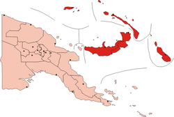
The Islands Region is one of four regions of Papua New Guinea (PNG) comprising the Bismarck Archipelago and north-eastern Solomon Islands Archipelago, located north-east of the mainland on eastern New Guinea island.
This is the least densely inhabited region of the country with a population of 750,000 (14% of PNG).[1]
It is distinct through its prehistory and history, as shown by the prevalence of Austronesian languages, and archeological findings of Lapita pottery culture.
Subdivision
The Region is administratively divided into five provinces:
- Autonomous Province of Bougainville (North Solomons)
- East New Britain
- Manus
- New Ireland
- West New Britain
References
- ↑ PNG Census 2000
See also
This article is issued from Wikipedia - version of the 10/16/2016. The text is available under the Creative Commons Attribution/Share Alike but additional terms may apply for the media files.