Hut Point Peninsula
Hut Point Peninsula is a long, narrow peninsula from 3 to 5 km (2 to 3 mi) wide and 24 km (15 mi) long, projecting south-west from the slopes of Mount Erebus on Ross Island, Antarctica. McMurdo Station (US) and Scott Base (NZ) are Antarctic research stations located on the Hut Point Peninsula.
History
The British National Antarctic Expedition (1901–04) under Robert Falcon Scott built its hut on Hut Point, a small point lying 1.5 km (1 mi) north-east of Cape Armitage, at the southern end of the peninsula. Members of the British Antarctic Expedition, 1910–13, under Scott, wintering on Cape Evans and often using the hut during their journeys, came to refer to the whole peninsula as the Hut Point Peninsula.[1][2]
Historic sites and monuments
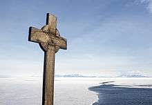
Several features on Hut Point, including the cross memorial for George Vince and the store hut for the Scott expeditions, are protected under the Antarctic Treaty.[2] Both the cross (HSM 19) and the hut (HSM 18) have been designated Historic Sites or Monuments, following proposals by New Zealand and the United Kingdom to the Antarctic Treaty Consultative Meeting.[3] The point is protected as Antarctic Specially Protected Area (ASPA) No.158 largely because of its historic significance as one of the principal sites of early human activity in Antarctica.[4]
See also
References
- ↑ "Hut Point Peninsula". Geographic Names Information System. United States Geological Survey. Retrieved 2012-07-05.
- 1 2 Stonehouse, Bernard. Encyclopedia of Antarctica and the Southern Oceans, John Wiley and Sons, 2002. ISBN 0-471-98665-8
- ↑ "List of Historic Sites and Monuments approved by the ATCM (2012)" (PDF). Antarctic Treaty Secretariat. 2012. Retrieved 2013-10-27.
- ↑ "Hut Point, Ross Island" (PDF). Management Plan for Antarctic Specially Protected Area No. 158: Measure 2, Annex K. Antarctic Treaty Secretariat. 2005. Retrieved 2013-06-12.
![]() This article incorporates public domain material from the United States Geological Survey document "Hut Point Peninsula" (content from the Geographic Names Information System).
This article incorporates public domain material from the United States Geological Survey document "Hut Point Peninsula" (content from the Geographic Names Information System).
Coordinates: 77°47′S 166°51′E / 77.783°S 166.850°E