Hollowhill and Pullingshill Woods
| Site of Special Scientific Interest | |
 | |
| Area of Search | Buckinghamshire |
|---|---|
| Grid reference | SU822862 |
| Interest | Biological |
| Area | 23.0 hectares |
| Notification | 1984 |
| Location map | Magic Map |
Hollowhill and Pullingshill Woods is a 23-hectare biological Site of Special Scientific Interest near Marlow in Buckinghamshire. It is in the Chilterns Area of Outstanding Natural Beauty, and the Chilterns Beechwoods Special Area of Conservation. The local planning authorities are Wycombe District Council and Buckinghamshire County Council.[1][2][3] Pullingshill Wood is owned by the Woodland Trust,[4] and Hollowhill Wood was formerly owned by Buckinghamshire County Council, but was transferred to the Berkshire, Buckinghamshire and Oxfordshire Wildlife Trust.[5][6] Since November 2015 the 7.8-hectare site has been managed by the Trust as "Hog and Hollowhill Woods".[3]
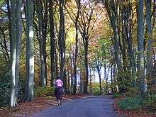
A large part of the site is mature beech woodland, the result of neglected coppicing. Much of the ground below the trees is bare, but there are some unusual plants, including the nationally rare ghost orchid. Trees on the lower slopes include ash, wild cherry and crab apple, and there is heather in more open areas.[1]
There is access from a road between Bockmer End and Hook Corner, which bisects the woods.
| Wikimedia Commons has media related to Hollowhill and Pullingshill Woods. |
References
- 1 2 "Pullingshill and Hollowhill Woods citation" (PDF). Sites of Special Scientific Interest. Natural England. Retrieved 28 September 2015.
- ↑ "Map of Pullingshill and Hollowhill Woods". Sites of Special Scientific Interest. Natural England. Retrieved 28 September 2015.
- 1 2 "Hog and Hollowhill Woods". Berkshire, Buckinghamshire and Oxfordshire Wildlife Trust. Retrieved 9 February 2016.
- ↑ "Pullingshill Wood and Marlow Common". Woodland Trust. Retrieved 28 September 2015.
- ↑ "Executive Officer Decision: Decision to proceed with the divestment of lands at Hog and Hollow Hill Woods" (PDF). Buckinghamshire County Council. 5 October 2014.
- ↑ "COMMUNITY WILDLIFE OFFICER (BUCKS)" (PDF). Berkshire, Buckinghamshire & Oxfordshire Wildlife Trust. Retrieved 28 September 2015.
Coordinates: 51°52′54″N 0°59′07″W / 51.8818°N 0.9852°W