Hlíðarfjall
| Hlíðarfjall | |
|---|---|
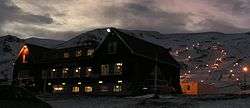
|
Hlíðarfjall lodge and ski slopes, Jan 2011 | |
| Highest point | |
| Elevation | 1,100 m (3,600 ft) |
| Coordinates | 65°38′55″N 18°15′57″W / 65.6487°N 18.2659°WCoordinates: 65°38′55″N 18°15′57″W / 65.6487°N 18.2659°W |
| Geography | |
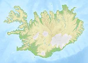 Hlíðarfjall Iceland | |
| Location | northern Iceland |
Akureyri, with Hlíðarfjall behind, viewed from the eastern shore of Eyjafjörður, morning November 2007
Hlíðarfjall (Icelandic pronunciation: [ˈl̥iːðar̥ˌfjatl̥]) is a mountain located west of the Icelandic town Akureyri in Eyjafjörður. It is the site of one of two major ski resorts in Iceland.[1] The former hotel no longer offers accommodation and is now mostly used for meetings.
Hlíðarfjall is generally considered to be named after Lögmannshlíð, a (formerly important) homestead and church site on the slopes of the mountain (the word hlíð having the meaning "slope").[2]
References
This article is issued from Wikipedia - version of the 8/21/2016. The text is available under the Creative Commons Attribution/Share Alike but additional terms may apply for the media files.