Hejnice (Liberec District)
| Hejnice | |||
| Town | |||
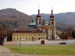 Pilgrimage Basilica of the Visitation and former Franciscan monastery | |||
|
|||
| Name origin: grove + village | |||
| Country | Czech Republic | ||
|---|---|---|---|
| Region | Liberec | ||
| District | Liberec | ||
| Commune | Frýdlant | ||
| Parts | Hejnice, Ferdinandov | ||
| River | Smědá | ||
| Elevation | 375 m (1,230 ft) | ||
| Coordinates | CZ 50°52′38″N 15°11′54″E / 50.87722°N 15.19833°ECoordinates: CZ 50°52′38″N 15°11′54″E / 50.87722°N 15.19833°E | ||
| Area | 38.19 km2 (14.75 sq mi) | ||
| Population | 2,735 (2005) | ||
| Density | 72/km2 (186/sq mi) | ||
| First mentioned | 1211 | ||
| Mayor | Jiří Horák | ||
| Timezone | CET (UTC+1) | ||
| - summer (DST) | CEST (UTC+2) | ||
| Postal code | 463 62 | ||
  Location in the Czech Republic | |||
| Wikimedia Commons: Hejnice (Liberec District) | |||
| Statistics: statnisprava.cz | |||
| Website: www.mestohejnice.cz | |||
Hejnice (Czech pronunciation: [ˈɦɛjɲɪtsɛ]; German: Haindorf) is a small town in the Liberec District in Liberec Region of the Czech Republic. From 1938 to 1945 it was one of the municipalities in Sudetenland. It is located under northern slopes of Jizera Mountains in 350–400 m above sea level in the valley of the river Smědá. It has about 2,600 inhabitants.
The village of Ferdinandov is an administrative part of Hejnice.
| Wikimedia Commons has media related to Hejnice (Liberec District). |
This article is issued from Wikipedia - version of the 4/4/2016. The text is available under the Creative Commons Attribution/Share Alike but additional terms may apply for the media files.