Guggersee
| Guggersee | |
|---|---|
 | |
| Location | Oberallgäu, Bavaria, Germany |
| Coordinates | 47°19′01″N 10°14′57″E / 47.31697°N 10.249166°ECoordinates: 47°19′01″N 10°14′57″E / 47.31697°N 10.249166°E |
| Primary outflows | into the Stillach |
| Max. width | 0.025 km (0.016 mi) |
| Surface area | 0.000843 km2 (0.000325 sq mi) |
| Shore length1 | 0.119 km (0.074 mi) |
| Surface elevation | 1,709 m (5,607 ft) |
| Islands | none |
| 1 Shore length is not a well-defined measure. | |
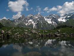
The Guggersee is a small mountain lake in the Southeastern Walsertal Mountains (Südöstliche Walsertaler Berge), a subgroup of the Allgäu Alps.
It is located at a height of 1,709 metres,[1] above the Rappenalpbach valley in the municipality of Oberstdorf. The lake lies 1,035 metres as the crow flies southwest of and below the Alpgundkopf (2,177 m) on a Panorama Way (Panoramaweg)[1] between Birgsau in the valley and the Mindelheim Hut (2,013 m). On this path, 455 metres southwest at a height of 1,727 metres, is the alm of Vordere Tauferbergsalpe. From Birgsau the lake is about 2 hours walk.
The lake is 49 metres long and a maximum of 25 metres wide. It has a shore length of 119 metres and an area of around 843 m².[2] Formerly it was up to 75 metres long, but the northern part has silted up.
References
- 1 2 Kompass walking, cycling and ski touring map: Sheet 03 Oberstdorf, Kleinwalsertal (1:25,000). ISBN 978-3-8549-1231-6 (as at: 2009).
- ↑ Bayerische Vermessungsverwaltung BayernViewer 2.0. Retrieved 20 January 2011 (measured from the aerial photograph)
External links
| Wikimedia Commons has media related to Guggersee. |
- Guggersee – Information about the lake at oberstdorf.de