Greater Accra Region
| Greater Accra Region | ||
|---|---|---|
| Region | ||
| ||
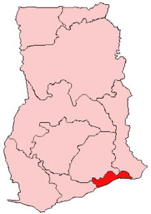 Location of Greater Accra Region in Ghana | ||
 Districts of Greater Accra | ||
| Country | Ghana | |
| Capital | Accra | |
| Districts | 16 | |
| Government | ||
| • Regional Minister | Joshua Nii Laryea Afotey-Agbo | |
| Area[1] | ||
| • Total | 3,245 km2 (1,253 sq mi) | |
| Area rank | Ranked 10th | |
| Population (2010 Census)[1] | ||
| • Total | 4,010,054 | |
| • Rank | Ranked 2nd | |
| • Density | 1,200/km2 (3,200/sq mi) | |
| GDP (PPP) | ||
| • Year | 2013 | |
| • Per capita | $5,150 | |
| GDP (Nominal) | ||
| • Year | 2013 | |
| • Per capita | $2,500 | |
| Time zone | GMT | |
| Area code(s) | 030 | |
| ISO 3166 code | GH-AA | |

The Greater Accra Region has the smallest area of Ghana's 10 administrative regions, occupying a total land surface of 3,245 square kilometres or 1.4 per cent of the total land area of Ghana. It is the second most populated region, after the Ashanti Region, with a population of 2,905,726 in 2000, accounting for 15.4 per cent of Ghana’s total population. The Greater Accra Region was part of the Eastern Region prior to 1982 and Greater Accra region was created from the Eastern Region in 1982 and currently harbors the seat of government in Accra.
History
In 1960, Greater Accra, then referred to as Accra Capital District, was geographically and legally part of the Eastern Region. It was, however, administered separately by the Minister responsible for local government. With effect from 23 July 1982, Greater Accra was created by the Greater Accra Region Law (PNDCL 26) as a legally separate region.[2]
Geography
Location and size
The Greater Accra Region is bordered on the north by the Eastern Region, on the east by the Lake Volta, on the south by the Gulf of Guinea, and on the west by the Central Region. It is smallest region of Ghana in total area, and is made up of 16 administrative areas.
Tourism
Parks
- Shai Reserve
Recreation areas
- National Museum
- La Pleasure Beach
- Kokrobite Beach
- Coco Beach Resort
- Cocoloco Beach
- Korle Beach Resort
- Next Door Beach Resort
- Manet Paradise
- Ada Paradise Beach
- Ningo-Prampram Beach
- Rufus Green Parks
- Labadi Beach
National monuments
- National Theater
- Independence Square
- Accra International Conference Center
- Center for National Culture
National historic sites
Other Tourist Attractions
- Fishing port at Jamestown
- Du Bois Memorial Center for Pan-African Culture
- George Padmore Research Library on African Affairs
- Agblobloshie Market
- Makola Market
- Trade Fair Center
Demographics
Population
The center of population of the Greater Accra region is located in the Greater Accra Metropolitan Area which comprises the Accra Metropolitan, Tema Metropolitan, Adenta Municipal, Ashaiman Municipal, Ledzokuku-Krowor Municipal, Ga East Municipal, Ga West Municipal, and Ga South Municipal districts[3]
According to the 2000 census, the region had a population of 2,905,726, making it the second most populous (total number of people) region of Ghana behind the Ashanti Region. Owing to in-migration and a high population growth rate, however, the region has the highest population density in the country.
Ethnicity and immigration
1.3% of the inhabitants of the Greater Accra Region are immigrants from outside Ghana.
The largest portion of the population of Accra is Akan, at 39.8% of the population. The next largest group is Ga-Dangme at 29.7% of the population. After this 18% of the population is Ewe.[4] The Ga sub-group of the Ga-Dangme people is the historical population of Accra. They form the largest ethnic sub-group in the Greater Accra Region, with 18.9% of the population. The Fante are the next largest ethnic sub-group, with 10% of the population.
Population Growth
In 1960 the population of the Greater Accra Region was 491,817. In 2000 the population was 2,905,726.[5]
Religion
The religious affiliations of the people of the Greater Accra region are below:[1]
Transportation
The Greater Accra region is served by the Kotoka International Airport in Accra. Four National highways – N1, N2, N4 and N6 – and one Regional highway – R40 – pass through the Greater Accra region.
N1 enters the region in Ada to the east and runs west, intersecting the N2 at Tema, the Tetteh Quarshie Interchange, and the N6 at Achimota. It passes through Kokrobite and exits the region at Weija where it continues on through the Central Region to Elubo in the Western region. The N2 crosses the Eastern Regional border into Asikuma and runs north entering the Upper East Region, ending at Kulungugu. The N4 heads north from the Tetteh Quarshie Interchange, while the N6 originates from Achimota. These highways cut through the northern part of the region and terminate at Kumasi in the Ashanti Region.
Education
Higher education
Greater Accra has two public four-year institutions, the University of Ghana in Accra and University of Professional Studies, East Legon, Accra. In addition, there are number of private universities and university colleges spread through the region.
- Ghana Technology University College, Tesano, Accra
- Islamic University College, East Legon, Accra
- Knutsford University College, East Legon, Accra
- Methodist University College, Dansoman, Accra
- Regent University College of Science and Technology, Mataheko, Accra
- Central University College, Mataheko/Miotso, Accra
- Advanced Business University College, Kaneshie, Accra
- African University College of Communications, Adabraka, Accra
- Wisconsin International University College, North Legon, Accra
- Valley View University, Oyibi, Accra
- Regional Maritime University, Nungua
- Pentecost University College, Sowutuom
- Maranatha University College, Sowutuom
- University of Applied Management, Ghana Campus, McCarthy Hill 18th Avenue
- Zenith University College, LA-Behind Ghana Trade Fair Centre, Accra
- Radford University College, East-Legon, Accra
Shopping Centers and their Locations
- Accra Mall - Tetteh Quarshie Roundabout
- Marina Mall - Airport Area
- West Hills Mall - weija
- Koala Shopping Center - Osu
- The Junction Mall- Nungua
Sports
- Accra Hearts of Oak, Premier League Football
- Liberty Professionals, Premier League Football
- Great Olympics, Football League
Districts
The political administration of the region is through the local government system. Under this administration system, the region is divided into 16 districts, as of June 2012 addition of 6 district areas.[1] Each District, Municipal or Metropolitan Area, is administered by a Chief Executive, representing the central government but deriving authority from an Assembly headed by a presiding member elected from among the members themselves.
| Districts in Greater Accra Region[6] | |||
|---|---|---|---|
| # | District | Capital | Population |
| 1 | Accra Metropolitan | Accra | |
| 2 | Tema Metropolitan | Tema | |
| 3 | Adenta Municipal | Adenta | |
| 4 | Ga East Municipal | Abokobi | |
| 5 | Ga West Municipal | Amasaman | |
| 6 | Ga South Municipal | Weija | |
| 7 | Ga Central Municipal | Sowutuom | |
| 8 | Ashiaman Municipal | Ashiaman | |
| 9 | Ledzokuku-Krowor | Teshie-Nungua | |
| 10 | Dangme East | Ada Foah | |
| 11 | Dangme West | Dodowa | |
| 12 | La Dade Kotopon | La | |
| 13 | La-Nkwantanang Madina | ||
| 14 | Kpone Katamanso | ||
| 15 | Ningo Prampram | ||
| 16 | Ada West | ||
| Total | |||
Famous native citizens
| Famous native citizens of Greater Accra | ||
|---|---|---|
| # | Citizen | Settlement |
| 1 | Joselyn Canfor Dumas | Accra |
| 2 | Sarkodie | Tema |
| 3 | Azumah Nelson | Accra |
| 4 | Arthur Wharton | Accra |
| 5 | Guy Warren | Accra |
| 6 | Asamoah Gyan | Accra |
| 7 | John D. Mahama | Accra |
References
- 1 2 3 4 "Greater Accra Region". Ghanadistricts.com. Retrieved 2015-05-19.
- ↑ Greater Accra Region - Political Administration
- ↑ "Environmental and Structural Inequalities in Greater Accra". The Journal of the International Institute. Retrieved 2010-07-22.
- ↑ Government of Ghana report on Greater Accra Region population
- ↑ Government of Ghana report on population of Greater Accra Region
- ↑ The Republic of Ghana - Administrative units
 |
Ashanti | |
Lake Volta | |
| |
|
Lake Volta | ||
| ||||
| | ||||
| Gulf of Guinea | Gulf of Guinea | Lake Volta Gulf of Guinea |