Grade I listed buildings in King's Lynn and West Norfolk

There are over 9,000 Grade I listed buildings in England. This page is a list of these buildings in the district of King's Lynn and West Norfolk in Norfolk.

King's Lynn and West Norfolk

Name Location Type Completed [note 1]Date designated Grid ref.[note 2]
Geo-coordinates
Entry number [note 3]Image
Church of St Andrew Barton Bendish Parish Church c.1200 8 July 1959 TF7121705687
52°37′19″N 0°31′41″E / 52.621948°N 0.527944°E / 52.621948; 0.527944 (Church of St Andrew)
1077860
Church of St Mary Barton Bendish Parish Church 14th century 8 July 1959 TF7097705437
52°37′11″N 0°31′27″E / 52.619778°N 0.524273°E / 52.619778; 0.524273 (Church of St Mary)
1077859
Ruins of Church of St James at TF 662 207 Bawsey Parish Church 11th century 20 June 1988 TF6620020700
52°45′30″N 0°27′41″E / 52.758342°N 0.461478°E / 52.758342; 0.461478 (Ruins of Church of St James at TF 662 207)
1077664
Church of St Mary Great Bircham, Bircham Parish Church Early 14th century 5 June 1953 TF7704632600
52°51′42″N 0°37′42″E / 52.861763°N 0.628468°E / 52.861763; 0.628468 (Church of St Mary)
1077807
Church of St Mary Brancaster Parish Church 12th century 5 June 1953 TF7724543900
52°57′47″N 0°38′15″E / 52.963169°N 0.637581°E / 52.963169; 0.637581 (Church of St Mary)
1237744
Church of St Mary Burnham Market Church c.1500 5 June 1953 TF8302242092
52°56′42″N 0°43′21″E / 52.944996°N 0.722471°E / 52.944996; 0.722471 (Church of St Mary)
1238100
Church of St Margaret Burnham Norton Parish Church Late 11th century 5 June 1953 TF8350142760
52°57′03″N 0°43′48″E / 52.950831°N 0.729969°E / 52.950831; 0.729969 (Church of St Margaret)
1238877
Gatehouse, Carmelite Friary Ruins Burnham Norton Carmelite Friary 1241 5 June 1953 TF8381542777
52°57′03″N 0°44′05″E / 52.950876°N 0.734647°E / 52.950876; 0.734647 (Gatehouse, Carmelite Friary Ruins)
1239045
Church of St Clement Burnham Overy Town, Burnham Overy Parish Church 12th century 5 June 1953 TF8430342929
52°57′07″N 0°44′31″E / 52.952074°N 0.741988°E / 52.952074; 0.741988 (Church of St Clement)
1239094
Church of All Saints Burnham Thorpe Parish Church 13th century 5 June 1953 TF8521641752
52°56′28″N 0°45′18″E / 52.941192°N 0.75489°E / 52.941192; 0.75489 (Church of All Saints)
1239270
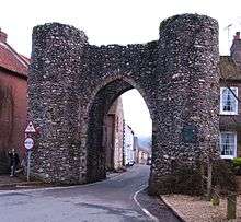
Bailey Gate Castle Acre Castle Gate 13th century 13 April 1987 TF8173115150
52°42′13″N 0°41′18″E / 52.70351°N 0.688299°E / 52.70351; 0.688299 (Bailey Gate)
1077681
Castle Acre Castle Castle Acre Castle Keep Mid 12th century 13 April 1987 TF8192015169
52°42′13″N 0°41′28″E / 52.703617°N 0.691103°E / 52.703617; 0.691103 (Castle Acre Castle)
1171480
Church of St James Castle Acre Parish Church c.1300 15 August 1960 TF8159815022
52°42′09″N 0°41′11″E / 52.702405°N 0.686262°E / 52.702405; 0.686262 (Church of St James)
1342386
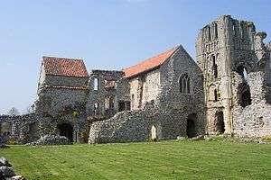
Remains of Cluniac Benedictine Priory of St Mary and St Peter and St Paul Castle Acre Priory (ruin) Norman 13 April 1987 TF8142614757
52°42′00″N 0°41′01″E / 52.700083°N 0.683573°E / 52.700083; 0.683573 (Remains of Cluniac Benedictine Priory of St Mary and St Peter and St Paul)
1342389
Remains of Gatehouse of Cluniac Priory of St Mary and St Peter and St Paul Castle Acre Gatehouse (ruin) 1090 13 April 1987 TF8136414940
52°42′06″N 0°40′58″E / 52.701747°N 0.682758°E / 52.701747; 0.682758 (Remains of Gatehouse of Cluniac Priory of St Mary and St Peter and St Paul)
1171437
Church of St Lawrence Castle Rising Parish Church 12th century 15 August 1960 TF6663824866
52°47′44″N 0°28′12″E / 52.795623°N 0.470081°E / 52.795623; 0.470081 (Church of St Lawrence)
1077602
Ruins of Castle and Eleventh Century Church Castle Rising Castle c.1138 21 February 1989 TF6657624554
52°47′34″N 0°28′08″E / 52.79284°N 0.469004°E / 52.79284; 0.469004 (Ruins of Castle and Eleventh Century Church)
1077599
Trinity Hospital (hospital of the Holy and Undivided Trinity) and attached Enclosing Walls, Circa 30 Metres East of Church of St Castle Rising Almshouses 1609-15 19 October 1951 TF6668624865
52°47′44″N 0°28′15″E / 52.795599°N 0.470792°E / 52.795599; 0.470792 (Trinity Hospital (hospital of the Holy and Undivided Trinity) and attached Enclosing Walls, Circa 30 Metres East of Church of St)
1342436
Church of St Nicholas Dersingham Parish Church 14th century 5 June 1953 TF6931130386
52°50′40″N 0°30′45″E / 52.844366°N 0.512544°E / 52.844366; 0.512544 (Church of St Nicholas)
1342317
Church of St Edmund Downham Market Church 15th century 24 February 1949 TF6127903305
52°36′13″N 0°22′48″E / 52.603593°N 0.380112°E / 52.603593; 0.380112 (Church of St Edmund)
1342608
Church of St Mary East Walton Parish Church 12th century 15 August 1960 TF7426716112
52°42′53″N 0°34′42″E / 52.714601°N 0.578461°E / 52.714601; 0.578461 (Church of St Mary)
1077667
Church of St Edmund Emneth Parish Church c.1210 11 August 1951 TF4885307383
52°38′38″N 0°11′55″E / 52.643769°N 0.198611°E / 52.643769; 0.198611 (Church of St Edmund)
1077736
Church of St Mary Feltwell Parish Church Mid 14th century 8 July 1959 TL7151890738
52°29′15″N 0°31′29″E / 52.487595°N 0.524664°E / 52.487595; 0.524664 (Church of St Mary)
1077715
Church of St Nicholas Feltwell Parish Church (redundant) 12th century 8 July 1959 TL7125690890
52°29′21″N 0°31′15″E / 52.489042°N 0.520888°E / 52.489042; 0.520888 (Church of St Nicholas)
1342364
Church of St Martin Fincham Parish Church Mid 15th century 8 July 1959 TF6880106458
52°37′47″N 0°29′34″E / 52.629628°N 0.492683°E / 52.629628; 0.492683 (Church of St Martin)
1077822
Church of St Mary Gayton Thorpe, Gayton Parish Church Early 12th century 15 August 1960 TF7450218526
52°44′10″N 0°35′00″E / 52.736204°N 0.583217°E / 52.736204; 0.583217 (Church of St Mary)
1077632
Church of St Nicholas Gayton Church 1604 15 August 1960 TF7302219262
52°44′36″N 0°33′42″E / 52.743289°N 0.561708°E / 52.743289; 0.561708 (Church of St Nicholas)
1077638
Church of St Mary Great Massingham Parish Church 13th century 15 August 1960 TF7987422949
52°46′27″N 0°39′54″E / 52.774163°N 0.665117°E / 52.774163; 0.665117 (Church of St Mary)
1171571
Church of St Botolph Grimston Parish Church 13th century 15 August 1960 TF7217021891
52°46′02″N 0°33′02″E / 52.767171°N 0.550479°E / 52.767171; 0.550479 (Church of St Botolph)
1342401
Church of St Lawrence Harpley Parish Church 13th century 15 August 1960 TF7887126067
52°48′09″N 0°39′07″E / 52.802495°N 0.651969°E / 52.802495; 0.651969 (Church of St Lawrence)
1077655
Church of St James Hockwold cum Wilton Parish Church Early 14th century 8 July 1959 TL7346888008
52°27′45″N 0°33′07″E / 52.46246°N 0.551933°E / 52.46246; 0.551933 (Church of St James)
1077725
Church of St Peter Hockwold cum Wilton Parish Church Mid 14th century 8 July 1959 TL7249188015
52°27′46″N 0°32′15″E / 52.462833°N 0.537572°E / 52.462833; 0.537572 (Church of St Peter)
1306877
Church of St Mary Holme-next-the-Sea Parish Church Perpendicular 5 June 1953 TF7070443429
52°57′40″N 0°32′24″E / 52.961059°N 0.54005°E / 52.961059; 0.54005 (Church of St Mary)
1171431
Church of St Martin Houghton Park, Houghton Parish Church 14th century 5 June 1953 TF7937028382
52°49′23″N 0°39′38″E / 52.823118°N 0.660632°E / 52.823118; 0.660632 (Church of St Martin)
1077787
Houghton Hall with Courtyard Walls Attached to North and South Houghton Park, Houghton Country House 1722-1735 5 June 1953 TF7916528789
52°49′37″N 0°39′28″E / 52.826841°N 0.657816°E / 52.826841; 0.657816 (Houghton Hall with Courtyard Walls Attached to North and South)
1152645
The Square, Houghton Hall Houghton Park, Houghton Stables c.1900 9 October 1985 TF7904728600
52°49′31″N 0°39′21″E / 52.825183°N 0.655963°E / 52.825183; 0.655963 (The Square, Houghton Hall)
1152782
The Watertower Houghton Park, Houghton Water Tower c.1733 9 October 1985 TF7899229464
52°49′59″N 0°39′20″E / 52.832959°N 0.655621°E / 52.832959; 0.655621 (The Watertower)
1342318
Church of St Andrew Little Massingham Parish Church 14th century 15 August 1960 TF7925824149
52°47′07″N 0°39′24″E / 52.785144°N 0.656653°E / 52.785144; 0.656653 (Church of St Andrew)
1171638
Church of Holy Trinity Marham Parish Church 12th century 8 July 1959 TF7081509737
52°39′30″N 0°31′27″E / 52.658447°N 0.524106°E / 52.658447; 0.524106 (Church of Holy Trinity)
1077832
Church of St George Methwold Church 1721 8 July 1959 TL7323794827
52°31′26″N 0°33′07″E / 52.523775°N 0.552082°E / 52.523775; 0.552082 (Church of St George)
1077730
The Old Vicarage Methwold House 16th century 9 July 1951 TL7321694764
52°31′24″N 0°33′06″E / 52.523216°N 0.55174°E / 52.523216; 0.55174 (The Old Vicarage)
1342369
Middleton Tower Tower End, Middleton House c.1455 19 October 1951 TF6686817564
52°43′48″N 0°28′11″E / 52.729972°N 0.469774°E / 52.729972; 0.469774 (Middleton Tower)
1077649
Church of St Mary North Creake Parish Church c.1300 5 June 1953 TF8541037729
52°54′18″N 0°45′20″E / 52.905003°N 0.755477°E / 52.905003; 0.755477 (Church of St Mary)
1077816
Creake Abbey Farmhouse North Creake Abbey Medieval 5 June 1953 TF8561539450
52°55′13″N 0°45′34″E / 52.920385°N 0.759504°E / 52.920385; 0.759504 (Creake Abbey Farmhouse)
1342331
Garden Walls Attached to North of Creake Abbey Farmhouse North Creake Abbey Medieval 18 April 1985 TF8561539475
52°55′14″N 0°45′34″E / 52.920609°N 0.759519°E / 52.920609; 0.759519 (Garden Walls Attached to North of Creake Abbey Farmhouse)
1304717
Remains of Creake Abbey Church North Creake Abbey 1206-1507 5 June 1953 TF8561339490
52°55′15″N 0°45′34″E / 52.920744°N 0.759497°E / 52.920744; 0.759497 (Remains of Creake Abbey Church)
1077815
Church of All Saints North Runcton Parish Church 1713 15 August 1960 TF6465015901
52°42′57″N 0°26′10″E / 52.715715°N 0.436126°E / 52.715715; 0.436126 (Church of All Saints)
1342408
Church of St Andrew Northwold Parish Church 13th century 8 July 1959 TL7558197006
52°32′33″N 0°35′16″E / 52.542595°N 0.587745°E / 52.542595; 0.587745 (Church of St Andrew)
1342348
Headstone 11 Metres South of South Aisle of St Andrew's Church Northwold Gravestone (illegible) 1740 11 December 1985 TL7558096984
52°32′33″N 0°35′16″E / 52.542397°N 0.587719°E / 52.542397; 0.587719 (Headstone 11 Metres South of South Aisle of St Andrew's Church)
1077773
Headstone 6 Metres South of South Aisle of St Andrew's Church Northwold Gravestone (illegible) 1768 11 December 1985 TL7558496988
52°32′33″N 0°35′16″E / 52.542432°N 0.58778°E / 52.542432; 0.58778 (Headstone 6 Metres South of South Aisle of St Andrew's Church)
1342349
Headstone 7 Metres South of South Aisle of St Andrew's Church Northwold Gravestone (illegible) 1796 11 December 1985 TL7558496987
52°32′33″N 0°35′16″E / 52.542423°N 0.587779°E / 52.542423; 0.587779 (Headstone 7 Metres South of South Aisle of St Andrew's Church)
1170386
Headstone to Sarah, 10 Metres South of South Porch of St Andrew's Church Northwold Gravestone 1761 11 December 1985 TL7557796985
52°32′33″N 0°35′16″E / 52.542407°N 0.587675°E / 52.542407; 0.587675 (Headstone to Sarah, 10 Metres South of South Porch of St Andrew's Church)
1077772
Church of St Mary Old Hunstanton Parish Church c.1860 5 June 1953 TF6890541980
52°56′55″N 0°30′45″E / 52.948615°N 0.512539°E / 52.948615; 0.512539 (Church of St Mary)
1077920
Detached Porch in Courtyard, Hunstanton Hall Old Hunstanton Country House 1618 5 June 1953 TF6917641823
52°56′50″N 0°30′59″E / 52.94712°N 0.516487°E / 52.94712; 0.516487 (Detached Porch in Courtyard, Hunstanton Hall)
1077922
Entrance Gate Curtain Walls and Barn to East of Hunstanton Hall Old Hunstanton Gate 1623 20 September 1984 TF6924041814
52°56′49″N 0°31′03″E / 52.947019°N 0.517434°E / 52.947019; 0.517434 (Entrance Gate Curtain Walls and Barn to East of Hunstanton Hall)
1171822
Hunstanton Hall Moat, Bridge and Garden and Forecourt Walls Old Hunstanton Country House 1487 5 June 1953 TF6919241813
52°56′49″N 0°31′00″E / 52.947025°N 0.51672°E / 52.947025; 0.51672 (Hunstanton Hall Moat, Bridge and Garden and Forecourt Walls)
1171725
Church of St Clement Outwell Parish Church 13th century 11 August 1951 TF5137203664
52°36′35″N 0°14′03″E / 52.609666°N 0.234108°E / 52.609666; 0.234108 (Church of St Clement)
1171520
Church of St Mary Magdalene Pentney Parish Church 12th century 15 August 1960 TF7208213856
52°41′42″N 0°32′42″E / 52.695039°N 0.544969°E / 52.695039; 0.544969 (Church of St Mary Magdalene)
1077623
Remains of Augustinian Priory Pentney Augustinian Monastery c.1130 19 October 1951 TF7009612155
52°40′49″N 0°30′53″E / 52.680389°N 0.514733°E / 52.680389; 0.514733 (Remains of Augustinian Priory)
1342419
Church of St James Runcton Holme Parish Church Early 12th century 8 July 1959 TF6172709488
52°39′32″N 0°23′23″E / 52.658995°N 0.389746°E / 52.658995; 0.389746 (Church of St James)
1077884
Wallington Hall Runcton Holme Country House Mid 18th century 9 July 1951 TF6272307588
52°38′30″N 0°24′13″E / 52.641632°N 0.403522°E / 52.641632; 0.403522 (Wallington Hall)
1342286
Ruins of Church of St Felix at TF 666 261 Sandringham Parish Church 14th century 15 August 1960 TF6660026100
52°48′24″N 0°28′13″E / 52.806718°N 0.470146°E / 52.806718; 0.470146 (Ruins of Church of St Felix at TF 666 261)
1168733
Church of St Mary Sedgeford Parish Church 12th century 5 June 1953 TF7072036483
52°53′55″N 0°32′12″E / 52.898676°N 0.536637°E / 52.898676; 0.536637 (Church of St Mary)
1172064
Church of All Saints Shouldham Parish Church 14th century 8 July 1959 TF6812708903
52°39′06″N 0°29′02″E / 52.651796°N 0.483979°E / 52.651796; 0.483979 (Church of All Saints)
1152173
Church of St Mary Snettisham Parish Church Late 14th century 5 June 1953 TF6904834281
52°52′46″N 0°30′38″E / 52.879428°N 0.510662°E / 52.879428; 0.510662 (Church of St Mary)
1304420
Church of St Mary South Creake Parish Church 13th century 5 June 1953 TF8552636232
52°53′29″N 0°45′23″E / 52.891521°N 0.756347°E / 52.891521; 0.756347 (Church of St Mary)
1077798
Church of All Saints Stanhoe Parish Church 13th century 5 June 1953 TF8020436880
52°53′57″N 0°40′40″E / 52.899148°N 0.677691°E / 52.899148; 0.677691 (Church of All Saints)
1304643
Stanhoe Hall Stanhoe House 1703 5 June 1953 TF7999736991
52°54′01″N 0°40′29″E / 52.900214°N 0.674678°E / 52.900214; 0.674678 (Stanhoe Hall)
1342334
Church of Holy Trinity Stow Bardolph Parish Church 12th century 8 July 1959 TF6284005645
52°37′27″N 0°24′15″E / 52.624145°N 0.404292°E / 52.624145; 0.404292 (Church of Holy Trinity)
1342291
Church of St Mary Syderstone Parish Church 12th century 5 June 1953 TF8330432665
52°51′37″N 0°43′17″E / 52.860254°N 0.721351°E / 52.860254; 0.721351 (Church of St Mary)
1153280
Church of Saint Clement Terrington St Clement Church 13th century 11 August 1951 TF5520420436
52°45′33″N 0°17′55″E / 52.759239°N 0.298552°E / 52.759239; 0.298552 (Church of Saint Clement)
1237112
Tower to Church of Saint Clement Terrington St. Clement Bell Tower 1501-1527 24 June 1987 TF5518620451
52°45′34″N 0°17′54″E / 52.759379°N 0.298292°E / 52.759379; 0.298292 (Tower to Church of Saint Clement)
1264263
Church of Saint John Terrington St John Bell Tower Late 13th century 11 August 1951 TF5393115853
52°43′06″N 0°16′39″E / 52.718436°N 0.277556°E / 52.718436; 0.277556 (Church of Saint John)
1264266
Church of All Saints Thornham Parish Church 13th century 5 June 1953 TF7337143446
52°57′37″N 0°34′47″E / 52.960357°N 0.579723°E / 52.960357; 0.579723 (Church of All Saints)
1342296
Church of All Saints Tilney All Saints Parish Church Late 12th century 11 August 1951 TF5683717973
52°44′12″N 0°19′18″E / 52.736645°N 0.321553°E / 52.736645; 0.321553 (Church of All Saints)
1264202
Church of St Mary Titchwell Parish Church 12th century 5 June 1953 TF7622043874
52°57′48″N 0°37′20″E / 52.963273°N 0.622323°E / 52.963273; 0.622323 (Church of St Mary)
1273641
Church of St Peter Upwell Parish Church 13th century 11 August 1951 TF5059302780
52°36′07″N 0°13′20″E / 52.601941°N 0.222211°E / 52.601941; 0.222211 (Church of St Peter)
1342359
Church of St Andrew Walpole Church Earlier Material 11 August 1951 TF5016217558
52°44′05″N 0°13′21″E / 52.73481°N 0.22258°E / 52.73481; 0.22258 (Church of St Andrew)
1264158
Church of St Peter Walpole Parish Church Early 14th century 11 August 1951 TF5021216879
52°43′43″N 0°13′23″E / 52.728697°N 0.223009°E / 52.728697; 0.223009 (Church of St Peter)
1264167
Church of All Saints Walsoken Church C20 11 August 1951 TF4772010544
52°40′21″N 0°11′00″E / 52.672475°N 0.183293°E / 52.672475; 0.183293 (Church of All Saints)
1171765
Church of Ss Peter and Paul Watlington Parish Church Late 13th century 8 July 1959 TF6210711195
52°40′27″N 0°23′46″E / 52.674214°N 0.396198°E / 52.674214; 0.396198 (Church of Ss Peter and Paul)
1077890
Church of All Saints West Acre Parish Church 14th century 15 August 1960 TF7808015237
52°42′20″N 0°38′04″E / 52.705503°N 0.634372°E / 52.705503; 0.634372 (Church of All Saints)
1342409
High House West Acre Country House Mid 18th century 19 October 1951 TF7928418126
52°43′52″N 0°39′13″E / 52.731049°N 0.653746°E / 52.731049; 0.653746 (High House)
1305453
High House Stable Court and Curtain Wall Attached at East of High House West Acre Brewery c.1829 13 April 1987 TF7934618152
52°43′53″N 0°39′17″E / 52.731262°N 0.654678°E / 52.731262; 0.654678 (High House Stable Court and Curtain Wall Attached at East of High House)
1342411
West Acre Priory Gatehouse West Acre Augustinian Monastery c.1100 19 October 1951 TF7805015231
52°42′20″N 0°38′02″E / 52.705459°N 0.633925°E / 52.705459; 0.633925 (West Acre Priory Gatehouse)
1077660
Church of St Andrew West Dereham Church 1710 8 July 1959 TF6674602104
52°35′28″N 0°27′37″E / 52.591157°N 0.460157°E / 52.591157; 0.460157 (Church of St Andrew)
1170580
Church of St Peter West Rudham Parish Church 13th century 5 June 1953 TF8195327642
52°48′56″N 0°41′55″E / 52.815608°N 0.698509°E / 52.815608; 0.698509 (Church of St Peter)
1153338
Bell Tower of Church of St Mary West Walton Bell Tower 1240-1250 28 July 1986 TF4712613318
52°41′51″N 0°10′33″E / 52.697555°N 0.175753°E / 52.697555; 0.175753 (Bell Tower of Church of St Mary)
1171875
Church of St Mary West Walton Parish Church c1240-1250 11 August 1951 TF4711313361
52°41′53″N 0°10′32″E / 52.697945°N 0.17558°E / 52.697945; 0.17558 (Church of St Mary)
1077676
Church of St Germans Wiggenhall St Germans Parish Church 13th century 8 July 1959 TF5969314015
52°42′01″N 0°21′43″E / 52.700259°N 0.361894°E / 52.700259; 0.361894 (Church of St Germans)
1077892
Church of St Mary the Virgin Wiggenhall St Germans Parish Church 13th century 8 July 1959 TF5826414404
52°42′15″N 0°20′27″E / 52.704172°N 0.340952°E / 52.704172; 0.340952 (Church of St Mary the Virgin)
1342293
Church of St Mary Magdalen Wiggenhall St Mary Magdalen Parish Church 13th century 8 July 1959 TF5986411374
52°40′35″N 0°21′47″E / 52.676487°N 0.363141°E / 52.676487; 0.363141 (Church of St Mary Magdalen)
1077896
Church of St Botolph Wormegay Parish Church Mid 12th century 26 April 1985 TF6530210904
52°40′14″N 0°26′36″E / 52.670636°N 0.443261°E / 52.670636; 0.443261 (Church of St Botolph)
1077838
Chapel of St Nicholas King's Lynn Chapel of Ease 1146 1 December 1951 TF6185320455
52°45′27″N 0°23′49″E / 52.75746°N 0.397002°E / 52.75746; 0.397002 (Chapel of St Nicholas)
1210545
Church of St Margaret King's Lynn Parish Church 1741 1 December 1951 TF6177219806
52°45′06″N 0°23′44″E / 52.751656°N 0.395483°E / 52.751656; 0.395483 (Church of St Margaret)
1211336
Clifton House King's Lynn House 17th century 1 December 1951 TF6165319937
52°45′10″N 0°23′38″E / 52.752868°N 0.393786°E / 52.752868; 0.393786 (Clifton House)
1210377
Custom House Including North Bank of Purfleet Quay King's Lynn Statue 1683 7 June 1972 TF6162720042
52°45′14″N 0°23′36″E / 52.753819°N 0.393452°E / 52.753819; 0.393452 (Custom House Including North Bank of Purfleet Quay)
1195414
Greyfriars Tower in Tower Gardens King's Lynn Church tower c.1230 1 December 1951 TF6201219787
52°45′05″N 0°23′56″E / 52.751413°N 0.399026°E / 52.751413; 0.399026 (Greyfriars Tower in Tower Gardens)
1195428
Guildhall King's Lynn Guildhall 1422-28 1 December 1951 TF6171619861
52°45′08″N 0°23′41″E / 52.752166°N 0.394681°E / 52.752166; 0.394681 (Guildhall)
1211953
Guildhall of St George King's Lynn Guildhall 1410-1420 1 December 1951 TF6161820224
52°45′20″N 0°23′36″E / 52.755456°N 0.393409°E / 52.755456; 0.393409 (Guildhall of St George)
1290960
Hampton Court King's Lynn Merchants House Early 14th century 1 December 1951 TF6173519740
52°45′04″N 0°23′42″E / 52.751074°N 0.394902°E / 52.751074; 0.394902 (Hampton Court)
1195430
Hanse House King's Lynn House Mid 18th century 1 December 1951 TF6172719766
52°45′05″N 0°23′41″E / 52.75131°N 0.394797°E / 52.75131; 0.394797 (Hanse House)
1195393
Red Mount Chapel King's Lynn Chapel C20 1 December 1951 TF6247019842
52°45′06″N 0°24′21″E / 52.75177°N 0.405832°E / 52.75177; 0.405832 (Red Mount Chapel)
1195403
South Gate King's Lynn Town Gate Late 13th century 1 December 1951 TF6219919157
52°44′45″N 0°24′05″E / 52.745699°N 0.401483°E / 52.745699; 0.401483 (South Gate)
1195304
Thoresby College King's Lynn Apartment 1963-4 1 December 1951 TF6167319849
52°45′07″N 0°23′39″E / 52.752071°N 0.394038°E / 52.752071; 0.394038 (Thoresby College)
1195418
28, 30, 32 King Street King's Lynn First Floor Hall House c.1180 1 December 1951 TF6165220175
52°45′18″N 0°23′38″E / 52.755006°N 0.393888°E / 52.755006; 0.393888 (28, 30, 32 King Street)
1195291

Notes

  1. The date given is the date used by Historic England as significant for the initial building or that of an important part in the structure's description.
  2. Sometimes known as OSGB36, the grid reference is based on the British national grid reference system used by the Ordnance Survey.
  3. The "List Entry Number" is a unique number assigned to each listed building and scheduled monument by Historic England.

Media related to Grade I listed buildings in Norfolk, England at Wikimedia Commons

This article is issued from Wikipedia - version of the 11/2/2016. The text is available under the Creative Commons Attribution/Share Alike but additional terms may apply for the media files.