Grímsey
| Grímsey | |
|---|---|
| Island | |
|
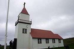
Grímsey Church in June 2008 | |
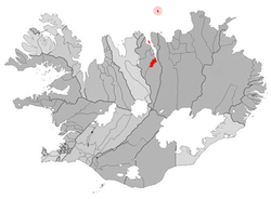 Location of the Municipality of Akureyri | |
 Grímsey Location of the island Grímsey | |
| Coordinates: 66°33′N 18°00′W / 66.550°N 18.000°W | |
| Country | Iceland |
| Constituency[1] | Northeast Constituency |
| Region[2] | Northeastern Region |
| Municipality | Akureyri |
| Area | |
| • Land | 5.3 km2 (2.0 sq mi) |
| Elevation | 105 m (344 ft) |
| Population | |
| • Total | 86 |
| Website | Official website |
Grímsey is a small Icelandic island, 40 kilometres (25 mi) off the north coast of the main island of Iceland and straddling the Arctic Circle. In January 2011 Grímsey had 86 inhabitants.[3] Until a vote in 2009 to amalgamate with Akureyri,[4] it constituted the hreppur (municipality) of Grímseyjarhreppur. The only settlement is Sandvík.[5]
Geography
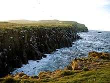
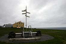
Grímsey is the northernmost inhabited Icelandic territory; the islet of Kolbeinsey lies farther north, but is uninhabited. The closest land is the island of Flatey, Skjálfandi, 39.4 kilometres (24.5 mi) to the south. The Arctic Circle runs through the island, while the entirety of mainland Iceland lies south of the Arctic Circle. (Due to long-term oscillations in the Earth's axis, the Arctic Circle currently shifts northward by about 14.5 metres per year.) There are steep cliffs everywhere except on the southern shoreline. Grímsey has an area of 5.3 square kilometres (2.0 sq mi), and a maximum elevation of 105 metres (344 ft).[6]
Climate
Despite the northerly latitude, the climate is generally mild, because of the North Atlantic Current, which brings warm water from the Gulf of Mexico. A maximum temperature of 26 °C (79 °F) has been recorded, which equals that of the much more southerly capital Reykjavík.
| Climate data for Grimsey | |||||||||||||
|---|---|---|---|---|---|---|---|---|---|---|---|---|---|
| Month | Jan | Feb | Mar | Apr | May | Jun | Jul | Aug | Sep | Oct | Nov | Dec | Year |
| Average high °C (°F) | 1 (33) |
0 (32) |
−1 (31) |
2 (35) |
4 (40) |
8 (47) |
9 (49) |
10 (50) |
8 (46) |
4 (40) |
2 (36) |
1 (34) |
4 (39) |
| Average low °C (°F) | −5 (23) |
−6 (22) |
−6 (21) |
−4 (25) |
−1 (31) |
3 (37) |
4 (40) |
5 (41) |
3 (37) |
0 (32) |
−3 (27) |
−4 (24) |
−1 (30) |
| Average precipitation mm (inches) | 13 (0.5) |
28 (1.1) |
15 (0.6) |
18 (0.7) |
18 (0.7) |
30 (1.2) |
33 (1.3) |
43 (1.7) |
53 (2.1) |
50 (2) |
33 (1.3) |
20 (0.8) |
360 (14) |
| Source: Weatherbase [7] | |||||||||||||
Biodiversity
Though treeless, the island's vegetation cover is rich, consisting of marshland, grass, and moss, and the island is home to many birds, especially auks.[8][9]
Economy and society
The principal industrial activity is commercial fishing. Agriculture and collecting seabirds' eggs are also common.[9] Grímsey is a popular tourist destination for visitors who wish to experience the Arctic Circle. The island is served by regular ferry and aircraft passenger services from the mainland.[5]
The church on Grímsey was built from driftwood in 1867 and renovated in 1956. It is within the parish of Akureyri. The island also features a community center and a school from kindergarten to Grade 8. Beyond this age, students travel to Akureyri for further education. The church was formerly a parsonage, and is situated at a place marked as Miðgarður on most maps of the island; however, the single settlement is officially known as Sandvík.
The island has acquired a long-standing reputation for being a bastion of chess-playing.[10] On learning this, the American scholar and keen chess player Willard Fiske took a protective interest in Grímsey in the 1870s, sending supplies, supporting the economy and leaving money in his will, though he never once visited.[11]
Transport
The island is served by Grímsey Airport. A ferry connects the island three days a week with the mainland.
See also
References
- ↑ Political division
- ↑ Mainly statistical division
- ↑ "Mannfjöldi eftir byggðakjörnum, kyni og aldri 1. janúar 1998-2011". Hagstofa Íslands. Retrieved 25 November 2011.
- ↑ "Grímsey og Akureyri sameinast", Morgunblaðið 26 April 2009 (Icelandic)
- 1 2 Swaney, Deanna (1997). Iceland, Greenland & the Faroe Islands (3rd ed.). Lonely Planet. pp. 251–252. ISBN 0-86442-453-1.
- ↑ "Um Grímsey". Grímseyjarhreppur. Retrieved 2008-10-28. (Icelandic)
- ↑ "Weatherbase: Historical Weather for Grimsey, Iceland". Weatherbase. 2011. Retrieved on November 24, 2011.
- ↑ Riley, Laura & William (2005). Nature's Strongholds: The World's Great Wildlife Reserves. Princeton University Press. p. 384. ISBN 978-0-691-12219-9.
- 1 2 BirdLife International (2015). Important Bird Areas factsheet: Grímsey. Downloaded from http://www.birdlife.org on 03/01/2015
- ↑ Tomasson, Richard F. (1980). Iceland, the First New Society. University of Minnesota Press. p. 50. ISBN 978-0-8166-0913-0.
- ↑ Millman, Lawrence; Theroux, Paul (2001). Last Places: A Journey in the North. Houghton Mifflin Books. pp. 109–110. ISBN 978-0-618-08248-3.
Sources
- Places along the way...Grímsey, published by Bókaútgafan að Hofi
Further reading
- Jack, Robert, Arctic Living: the Story of Grimsey, [with] foreword by Vilhjalmur Stefansson, Toronto, Ont.: Ryerson Press, 1955.
External links
| Wikimedia Commons has media related to Grímsey. |
Coordinates: 66°33′N 18°00′W / 66.550°N 18.000°W