Fernmeldeturm Berlin
The Fernmeldeturm Berlin (Telecommunications Tower Berlin) is a telecommunication tower located atop the Schäferberg hill in Berlin-Wannsee. The tower was built between 1961 and 1964, and is not open to the public. Owner and operator of the site is Deutsche Funkturm (DFMG), a subsidiary of Deutsche Telekom.
The Fernmeldeturm Berlin is 212 metres (696 ft) tall, and its steel-reinforced concrete shaft extends to a height of 187 metres (614 ft). Between 101 and 132 metres (331 and 433 ft) in elevation, the tower houses six floors for technical equipment. This currently consists of transmitters for DVB-T digital television, analog FM radio, and newer DAB and DMB digital radio.
From 1964 to the early nineties, the tower was also used to implement an over horizon radio relay link to the rest of West Germany (counterparts at Torfhaus and Clenze). To that end the tower was equipped with two parabolic dish antennas, each 18 metres (59 ft) in diameter, which were mounted on the lower portion of the tower. They were removed in 1996. Because of these aerials, the Fernmeldeturm Berlin had to be designed to withstand triple the wind loading of the comparably sized TV tower in Stuttgart. The concrete shaft is thus 12 metres (39 ft) in diameter at the bottom, with a wall thickness of 55 centimetres (22 in). At the 97-metre (318 ft) mark, the shaft is nigh 7 metres (23 ft) in diameter.
Directly adjacent to the Fernmeldeturm Berlin is a free standing steel framework tower, which formerly supported two 10-metre (33 ft) diameter parabolic aerials for an over horizon radio relay link, but these have since been removed. It is now predominantly used for cellular network aerials.
Since 2001, the Fernmeldeturm Berlin is also used for transmissions in the medium-wave range on 1485 kHz in DRM mode. Since the tower was not designed to accommodate this frequency range, a long wire aerial was installed for this purpose.
Gallery
-

The Fernmeldeturm viewed from the Belvedere Palace in Potsdam
-

The Fernmeldeturm viewed from Große Steinlanke
-
.jpg)
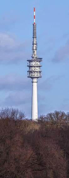
Tower viewed across Pohlesee
-

Commemorative Berlin postage stamp from 1965
-

Line drawing of the Fernmeldeturm showing its 1975 state
-
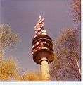
The Fernmeldeturm sporting its former antenna array
See also
External links
- Fernmeldeturm Berlin-Schäferberg at Structurae
- Picture on Google-Maps
- "Over the Top" describes Fernmeldeturm's role in the Cold War
Coordinates: 52°25′02″N 13°07′39″E / 52.41722°N 13.12750°E