Ermin Way
Not to be confused with Ermine Street, the Roman road connecting London and York
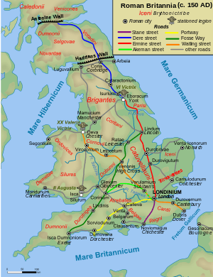
Ermin Street or Ermin Way was a Roman road in Britain. It linked Glevum (Gloucester) to Corinium (Cirencester) to Calleva (Silchester).
At Glevum, it connected to the road to Isca (Caerleon), the legionary base in southeast Wales. At Corinium, it connected to the Fosse Way between Isca (Exeter) and Lindum (Lincoln). At Calleva, it connected to the Devil's Highway to Londinium (London) and the Kentish ports, as well as to other routes to points in the southwest.
Much of it is now covered by the modern A417, A419 and B4000 roads.
See also
Coordinates: 51°37′39″N 1°49′12″W / 51.62739°N 1.81987°W
This article is issued from Wikipedia - version of the 11/28/2016. The text is available under the Creative Commons Attribution/Share Alike but additional terms may apply for the media files.