Dorset Heaths

The Dorset Heaths form an important area of heathland within the Poole Basin[1] in southern England. Much of the area is protected.
Extent
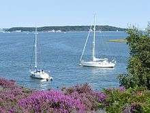
According to Natural England, who have designated the Dorset Heaths as National Character Area 135, the heathlands cover an area of 61,662 hectares, whose boundary runs from Bockhampton and Warmwell in the west via Wimborne Minster to Fordingbridge in the far northeast. It then turns southwards to Hengistbury Head, before following the coastline to Studland, and finally heading westwards - north of South Purbeck (with the Purbeck Hills) and the Weymouth Lowlands - to the Warmwell area.[2]
Character
The character of the Dorset Heaths contrasts strongly with its neighbouring natural regions. Undulating lowland heath with heather, pines and gorse alternates with exposed, open, large-scale farmland, woodland and scrub. Blocks of conifers form locally prominent landmarks. Apart from the major Poole-Bournemouth-Christchurch conurbation on the coast, much of the area is sparsely populated with scattered settlements and a few small villages and towns. Valleys are flat-bottomed and open with floodplain pastures. There is an outer perimeter of low, rolling hills marking the transition to chalk downland.[3]
Geography
Topography
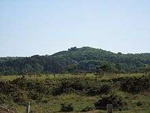
The land within the Dorset Heaths rises to a maximum of 193 metres (633 ft) at Creech Barrow Hill,[4][5][6][7] but the average height is just 32 metres (105 ft).
Rivers
Major rivers include the Frome, Stour, Moors, Piddle, Sherford, Allen, Corfe and Dorset Avon.[2]
Main settlements
The largest settlement within the Dorset Heaths is the extensive Poole / Bournemouth / Christchurch conurbation. Other significant towns are Wareham, Fordingbridge and Wimborne Minster. The total population for the NCA is 446,296 as at 2001.[2]
Protected areas

The Dorset Heaths are home to a large number of protected areas including:
- Ramsar sites and Special Protection Areas: Dorset Heathlands SPA, Poole Harbour SPA, Avon valley SPA
- Special areas of conservation: Dorset Heaths SAC, Dorset Heaths (Purbeck & Wareham) & Studland Dunes SAC, Isle of Portland to Studland Cliffs SAC; River Avon SAC.
- National nature reserves: Studland and Godlingston Heath NNR, Holt Heath NNR; Hartland Moor NNR; Stoborough Heath NNR; Holton Heath NNR; Morden Bog NNR; Arne Reedbeds NNR.[2]
References
- ↑ Part of the Hampshire Basin
- 1 2 3 4 NCA 135: Dorset Heaths Key Facts & Data at www.naturalengland.org.uk. Accessed on 3 Apr 2013.
- ↑ Dorset Heaths at www.naturalengland.org.uk. Accessed on 4 Sep 2013
- ↑ Database of British and Irish Hills, Appendix P30, v2.1
- ↑ Ordnance Survey 1:50,000 Landranger map series
- ↑ Dorset Heaths - Natural Area Profile, by English Nature, Oct 1997, at www.naturalareas.naturalengland.org.uk. Accessed on 3 Apr 2013.
- ↑ Note that Natural England's NCA profile gives the highest point as 174 m, but clearly implies Creech Barrow Hill is part of the NCA. English Nature give the height as 195 m.