Dolenji Radenci
| Dolenji Radenci | |
|---|---|
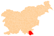
 Dolenji Radenci Location in Slovenia | |
| Coordinates: 45°27′58.58″N 15°5′55.79″E / 45.4662722°N 15.0988306°ECoordinates: 45°27′58.58″N 15°5′55.79″E / 45.4662722°N 15.0988306°E | |
| Country |
|
| Traditional region | White Carniola |
| Statistical region | Southeast Slovenia |
| Municipality | Črnomelj |
| Area | |
| • Total | 7.12 km2 (2.75 sq mi) |
| Elevation | 185.4 m (608.3 ft) |
| Population (2002) | |
| • Total | 35 |
| [1] | |
Dolenji Radenci (pronounced [dɔˈleːnji ɾaˈdeːntsi]; German: Unterradenze[2]) is a small settlement on the left bank of the Kolpa River in the Municipality of Črnomelj in the White Carniola area of southeastern Slovenia. The area is part of the traditional region of Lower Carniola and is now included in the Southeast Slovenia Statistical Region.[3]
There is a small chapel-shrine in the settlement dedicated to the Virgin Mary. It bears the date 1868.[4]
References
- ↑ Statistical Office of the Republic of Slovenia
- ↑ Leksikon občin kraljestev in dežel zastopanih v državnem zboru, vol. 6: Kranjsko. 1906. Vienna: C. Kr. Dvorna in Državna Tiskarna, p. 8.
- ↑ Črnomelj municipal site
- ↑ Slovenian Ministry of Culture register of national heritage reference number ešd 25571
External links
This article is issued from Wikipedia - version of the 4/27/2014. The text is available under the Creative Commons Attribution/Share Alike but additional terms may apply for the media files.