Coqueza Canton
| Coqueza | |
|---|---|
| Canton | |
|
The village of Coqueza with the Salar de Uyuni in the background | |
 Coqueza Location of Coqueza within Bolivia | |
| Coordinates: BO 19°54′5″S 67°37′32″W / 19.90139°S 67.62556°W | |
| Country |
|
| Department | Potosí Department |
| Province | Daniel Campos Province |
| Municipality | Tahua Municipality |
| Seat | Coqueza |
| Population (2001) | |
| • Total | 102 |
| Time zone | BST (UTC-4) |

Coqueza (also spelled Coquesa) is one of the cantons of the Tahua Municipality, the second municipal section of the Daniel Campos Province in the Potosí Department of Bolivia. During the census of 2001 it had 102 inhabitants.[1] Its seat is Coqueza. The village is situated at the Salar de Uyuni and south of the Tunupa volcano.
See also
References
- ↑ Instituto Nacional de Estadística, Bolivia Archived September 24, 2011, at the Wayback Machine. (Spanish)
External links
Capital: Potosí | ||
| Provinces | 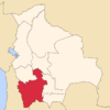 | |
| Municipalities (and seats) |
| |
This article is issued from Wikipedia - version of the 11/30/2016. The text is available under the Creative Commons Attribution/Share Alike but additional terms may apply for the media files.