Colebatch, Shropshire
| Colebatch | |
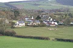 Colebatch seen from the Shropshire Way |
|
 Colebatch |
|
| Population | 210 (2011) |
|---|---|
| OS grid reference | SO318870 |
| Civil parish | Colebatch |
| Unitary authority | Shropshire |
| Ceremonial county | Shropshire |
| Region | West Midlands |
| Country | England |
| Sovereign state | United Kingdom |
| Post town | BISHOPS CASTLE |
| Postcode district | SY9 |
| Dialling code | 01588 |
| Police | West Mercia |
| Fire | Shropshire |
| Ambulance | West Midlands |
| EU Parliament | West Midlands |
| UK Parliament | Ludlow |
|
|
Coordinates: 52°28′37″N 3°00′14″W / 52.477°N 3.004°W
Colebatch is a small village and civil parish in southwest Shropshire, England. The population of the Civil Parish as at the 2011 census was 210.[1]
The village lies on the A488, one mile south of Bishop's Castle, on the road to Clun. Also nearby, to the east, is the village of Lydbury North, while the hamlet of Cefn Einion lies to the west.
In the village, on the west side of a tributary of the River Kemp, are the earthwork remains of Colebatch Castle, a small motte castle.
References
- ↑ "Civil Parish population 2011". Retrieved 22 November 2015.
External links
![]() Media related to Colebatch, Shropshire at Wikimedia Commons
Media related to Colebatch, Shropshire at Wikimedia Commons
| Unitary authorities | |
|---|---|
| Major settlements | |
| Rivers | |
| Canals | |
| Topics | |
This article is issued from Wikipedia - version of the 1/24/2016. The text is available under the Creative Commons Attribution/Share Alike but additional terms may apply for the media files.