Chickamin Glacier (Washington)
| Chickamin Glacier | |
|---|---|
|
Chickamin Glacier as it looked in 1965 | |
 Chickamin Glacier Location in Washington | |
| Type | Alpine glacier |
| Location | Chelan County, Washington, U.S. |
| Coordinates | 48°18′39″N 121°01′09″W / 48.31083°N 121.01917°WCoordinates: 48°18′39″N 121°01′09″W / 48.31083°N 121.01917°W[1] |
| Length | 1.60 mi (2.57 km) |
| Terminus | Icefall/Barren rock |
| Status | Retreating |
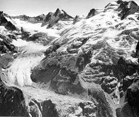
Chickamin Glacier is in the U.S. state of Washington. Chickamin Glacier is in Wenatchee National Forest and flows north from Dome Peak and Sinister Peak, descending from nearly 8,600 to 5,600 ft (2,600 to 1,700 m).[2] Chickamin Glacier is separated from Dome Glacier to the south and Dana Glacier to the west by arêtes. The relatively narrow tongue of the 2-mile (3.2 km) wide glacier retreated 800 ft (240 m) between 1998 and 2006.
See also
References
- ↑ "Chickamin Glacier". Geographic Names Information System. United States Geological Survey. Retrieved March 10, 2013.
- ↑ Dome Peak, WA (Map). TopoQwest (United States Geological Survey Maps). Retrieved March 10, 2013.
This article is issued from Wikipedia - version of the 12/24/2015. The text is available under the Creative Commons Attribution/Share Alike but additional terms may apply for the media files.