Centretown
| Centretown | |
|---|---|
| Neighbourhood | |
 Location of Centretown Ottawa in Ottawa | |
| Coordinates: 45°24′40″N 75°41′40″W / 45.41111°N 75.69444°WCoordinates: 45°24′40″N 75°41′40″W / 45.41111°N 75.69444°W | |
| Country | Canada |
| Province | Ontario |
| City | Ottawa |
| Government | |
| • Governing body | Centretown Citizens Community Association |
| • President | Tomas Whillans[1] |
| • MPs | Catherine McKenna |
| • MPPs | Yasir Naqvi |
| • Councillors | Catherine McKenney |
| Area | |
| • Total | 2.1 km2 (0.81 sq mi) |
| Elevation | 75 m (250 ft) |
| Population (2011) | |
| • Total | 21,536 |
| • Density | 9,768.1/km2 (24,324.7/sq mi) |
| Canada 2011 Census | |
| Time zone | Eastern (EST) (UTC-5) |
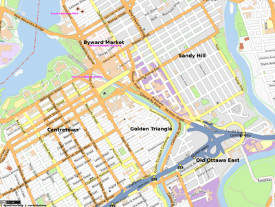
Centretown is a neighbourhood in Somerset Ward, in central Ottawa, Canada. It is defined by the city as "the area bounded on the north by Gloucester Street and Lisgar Street, on the east by the Rideau Canal, on the south by the Queensway freeway and on the west by Bronson Avenue."[2] Traditionally it was all of Ottawa west of the Rideau Canal, while Lower Town was everything to the east. For certain purposes, such as the census and real estate listings, the Golden Triangle and/or Downtown Ottawa (between Gloucester/Lisgar and the Ottawa River) is included in Centretown and it is considered part of Centretown by the Centretown Citizens Community Association[3] as well as being used in this way in casual conversation.
The total population of Centretown (south of Gloucester Street) was 21,536 according to the Canada 2011 Census.[4]
Centretown is marked by a mix of residential and commercial properties. The main streets such as Bank Street and Elgin Street are largely commercial, while the smaller ones, notably MacLaren and Gladstone are more residential. Much of the area still consists of original single family homes, but there are newer infill and town house developments and low-rise and high-rise apartment buildings. A construction boom that began in the late nineties significantly increased the number of condominiums and other residential and commercial high-rise buildings north of Cooper Street.
Landmarks include the Canadian Museum of Nature, Dundonald Park, Jack Purcell Park, the Ottawa Curling Club, the Sens Mile and the Ottawa Central Bus Station.
Demographics
According to the Canada 2006 Census. Defined as the area of Ottawa bounded on the west by Bronson, north by Gloucester Street, east by the Rideau Canal and on the south by the Queensway.
- Population: 20,513
- Change (2001–2006): -3.1%
- Total Private Dwellings: 14,040
- Land Area: 2.1 km².
- Population density: 9768.1 per km².
Precise number are difficult because of the large contingent of transient resident of the neighborhood, many of whom are students or hill staffer temporarily living in Ottawa.
Mid-Centretown Design Study
In 2009, the City of Ottawa launched a Mid-Centretown Community Design Plan study, which was to cover the area roughly bounded by "Elgin Street on the east, the 417 on the south, Kent Street on the west and the Central Area boundary/Gloucester Street on the north". Since that time, the study has come to encompass the entirety of Centretown. The design plan is targeted for completion in the fall of 2012.
Members of Parliament
The area was represented by two members from 1872 to 1935
- Joseph Merrill Currier, Liberal-Conservative (1867–1882); Ottawa (City of)
- John Bower Lewis, Conservative (1872–1874); Ottawa (City of)
- Pierre St. Jean, Liberal (1874–1878); Ottawa (City of)
- Joseph Tassé, Conservative (1878–1887); Ottawa (City of)
- Charles H. Mackintosh, Conservative (1882–1887); Ottawa (City of)
- W. G. Perley, Conservative (1887–1890); Ottawa (City of)
- Honoré Robillard, Liberal-Conservative (1887–1896); Ottawa (City of)
- Charles H. Mackintosh, Conservative (1890–1893); Ottawa (City of)
- James Alexander Grant, Conservative (1893–1896); Ottawa (City of)
- William H. Hutchison, Liberal (1896–1900); Ottawa (City of)
- N. A. Belcourt, Liberal (1896–1907); Ottawa (City of)
- Thomas Birkett, Conservative (1900–1904); Ottawa (City of)
- Robert Stewart, Liberal (1904–1908); Ottawa (City of)
- J. B. T. Caron, Liberal (1907–1908); Ottawa (City of)
- Sir Wilfrid Laurier, Liberal (1908–1910); Ottawa (City of)
- Harold B. McGiverin, Liberal (1908–1911); Ottawa (City of)
- Albert Allard, Liberal (1910–1911); Ottawa (City of)
- Alfred Ernest Fripp, Conservative (1911–1921); Ottawa (City of)
- John Léo Chabot, Conservative (1911–1921); Ottawa (City of)
- Harold B. McGiverin, Liberal (1921–1925); Ottawa (City of)
- Edgar Rodolphe Chevrier, Liberal (1921–1925); Ottawa (City of)
- Stewart McClenaghan, Conservative (1925–1926); Ottawa (City of)
- John Léo Chabot, Conservative (1925–1926); Ottawa (City of)
- Edgar Rodolphe Chevrier, Liberal (1926–1935); Ottawa (City of)
- Gordon Cameron Edwards, Liberal (1926–1930); Ottawa (City of)
- Thomas Franklin Ahearn, Liberal (1930–1940); Ottawa (City of) to 1935. Ottawa West from 1935
- George McIlraith, Liberal (1940–1972); Ottawa West to 1968. Ottawa Centre from 1968
- Hugh Poulin, Liberal (1973–1978); Ottawa Centre
- Robert de Cotret, Progressive Conservative (1978–1979); Ottawa Centre
- John Evans, Liberal (1979–1984); Ottawa Centre
- Michael Cassidy, NDP (1984–1988); Ottawa Centre
- Mac Harb, Liberal (1988–2003); Ottawa Centre
- Ed Broadbent, NDP (2004–2005)
- Paul Dewar, NDP (2006–2015)
- Catherine McKenna, Liberal (2015–present)
Centretown churches
- Centretown United Church
- Church of St. Barnabas, Apostle and Martyr
- First Church of Christ, Scientist
- First United Church
- Holy Korean Martyrs Parish
- Metropolitan Bible Church
- Salvation Army Gladstone Community Church
- St. George's Anglican Church
- St Patrick's Basilica
Centretown embassies
- Embassy of the Czech Republic in Ottawa
- Embassy of the Federal Republic of Germany in Ottawa
- Embassy of the Hellenic Republic in Ottawa
- Embassy of the Republic of Croatia in Ottawa
- Embassy of Iran in Ottawa
- Embassy of Iraq in Ottawa
- Embassy of the Republic of Madagascar in Ottawa
- High Commission of the Federal Republic of Nigeria in Ottawa
- Embassy of the Republic of Rwanda in Ottawa
- Embassy of the Republic of Zimbabwe in Ottawa
- Embassy of the Republic of Hungary in Ottawa
- Embassy of El Salvador in Ottawa
- Embassy of Ukraine in Ottawa
See also
| Wikimedia Commons has media related to Centretown. |
References
- ↑ http://www.centretowncitizens.ca
- ↑ Former Ottawa 3.1 Location
- ↑ Centretown Citizens' Community Association - About Us Archived August 28, 2008, at the Wayback Machine.
- ↑ Population is calculated from combining Census Tracts 5050040.00, 5050039.00, 5050038.00, 5050037.0 and 5050049.00
- Bibliography
- Burns,, Mrs. John C. (1981), Stewarton, a suburb of Ottawa. Bytown pamphlet series, Ottawa, Ontario: The Historical Society of Ottawa
External links
 |
LeBreton Flats | Downtown Ottawa | Lowertown | |
| Centretown West | |
Sandy Hill | ||
| ||||
| | ||||
| The Glebe | Old Ottawa East |