Capira District
| Capira District | |
|---|---|
| District | |
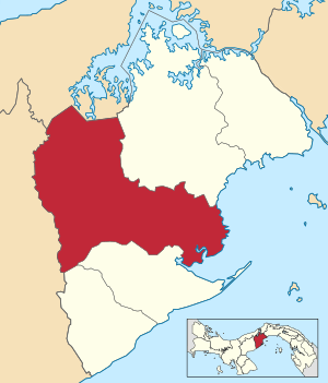 | |
 Capira District Location of the district capital in Panama | |
| Coordinates: 8°45′0″N 79°52′12″W / 8.75000°N 79.87000°WCoordinates: 8°45′0″N 79°52′12″W / 8.75000°N 79.87000°W | |
| Country |
|
| Province | West Panamá Province |
| Capital | Capira |
| Area | |
| • Total | 360 sq mi (933 km2) |
| Population (2000) | |
| • Total | 33,110 |
| Time zone | ETZ (UTC-5) |
Capira District is a district (distrito) of West Panamá Province in Panama. The population according to the 2000 census was 33,110.[1]The district covers a total area of 933 km². The capital is the city of Capira.[1]
Administrative divisions
The district is divided administratively into the following corregimientos:
Capira (capital), Caimito, Campana, Cermeño, Cirí de Los Sotos, Cirí Grande, El Cacao, La Trinidad, Las Ollas Arriba, Lídice, Villa Carmen, Villa Rosario and Santa Rosa.
References
- 1 2 "Districts of Panama". Statoids. Retrieved April 12, 2009.
Capital: La Chorrera | ||
| Arraiján District |  | |
| Capira District | ||
| Chame District | ||
| La Chorrera District | ||
| San Carlos District | ||
| Bocas del Toro Province | |
|---|---|
| Chiriquí Province | |
| Coclé Province | |
| Colón Province | |
| Darién Province | |
| Herrera Province | |
| Los Santos Province | |
| Panamá Province | |
| Veraguas Province | |
| West Panamá Province | |
This article is issued from Wikipedia - version of the 8/16/2016. The text is available under the Creative Commons Attribution/Share Alike but additional terms may apply for the media files.