CR postcode area
Postcode district boundaries: Bing / Google
| Croydon postcode area | |
|---|---|
 CR | |
| Postcode area | CR |
| Postcode area name | Croydon |
| Post towns | 10 |
| Postcode districts | 11 |
| Postcode sectors | 66 |
| Postcodes (live) | 8,114 |
| Postcodes (total) | 13,943 |
| Statistics as at February 2012[1] | |
The Croydon (CR) postcode area[2] is a group of nine postcode districts in England, which are subdivisions of eight post towns in southern Greater London and north-east Surrey.
The main sorting office is in Croydon, and the area served includes most of the London Borough of Croydon, the southeastern part of the London Borough of Merton and a small part of the London Borough of Sutton and London Borough of Bromley. Most of CR3 and CR6 cover the northern part of the Tandridge district of Surrey, and the southern part of CR5 covers a small part of the borough of Reigate and Banstead.
Croydon was the second town to have experimental postcodes, introduced in 1966 (Norwich having been the first). The system originally introduced included the postcode area CRO (letter 'O'), while Norwich used NOR for its equivalent. It was decided that the outward (first) part of a postcode should be alphanumerical, so CRO became CR0 (digit '0') and NOR became NR1. The CR1 postcode has not been introduced, making CR the only postcode area with a district 0 but not a district 1. Another lasting consequence of the experiment is that CR9 is allocated to large users, the only UK post town to have its high-volume addresses segregated non-geographically.
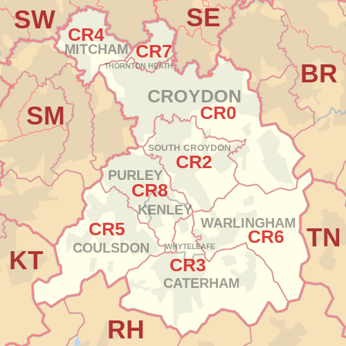
Coverage
The approximate coverage of the postcode districts:
Delivery Offices
Delivery offices are located at Croydon, South Croydon, Caterham, Mitcham, Coulsdon, Thornton Heath and Purley.[3]
Map
See also
References
- ↑ "ONS Postcode Directory Version Notes" (ZIP). National Statistics Postcode Products. Office for National Statistics. February 2012. Table 2. Retrieved 21 April 2012. Coordinates from mean of unit postcode points, "Code-Point Open". OS OpenData. Ordnance Survey. February 2012. Retrieved 21 April 2012.
- ↑ Royal Mail, Address Management Guide, (2004)
- ↑ https://www.whatdotheyknow.com/request/7870/response/20023/attach/2/Delivery%20Offices%20by%20postcodes.pdf