Cùl Beag
| Cùl Beag | |
|---|---|
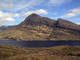 View of Cùl Beag from the south west, April 2009 | |
| Highest point | |
| Elevation | 769 m (2,523 ft) |
| Prominence | 546 m (1,791 ft) [1] |
| Listing | Marilyn, Corbett |
| Coordinates | 58°01′46″N 5°09′03″W / 58.02945°N 5.15091°WCoordinates: 58°01′46″N 5°09′03″W / 58.02945°N 5.15091°W |
| Naming | |
| Translation | small back (Gaelic) |
| Geography | |
| OS grid | NC140088 |
| Topo map | OS Landranger 15, Explorer 439 |

Cùl Beag is a mountain in Assynt, in the Northwest Highlands of Scotland. It is 15 km north of Ullapool and lies to the south of Cùl Mòr, and to the east of the more well known but lower Stac Pollaidh.
Cùl Beag is within the Drumrunie Estate, which was purchased in a community buyout in 2005. It is now owned by the Assynt Foundation.[2]
References
| Wikimedia Commons has media related to Cùl Beag. |
- ↑ Database of British and Irish Hills. Retrieved 20 Jan 2012
- ↑ "Assynt group buys estates in deal". BBC News. 3 June 2005. Retrieved 19 May 2013.
This article is issued from Wikipedia - version of the 12/6/2015. The text is available under the Creative Commons Attribution/Share Alike but additional terms may apply for the media files.