Benarty Hill
| Benarty Hill | |
|---|---|
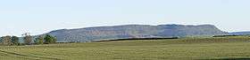 Benarty Hill from the north | |
| Highest point | |
| Elevation | 356 m (1,168 ft) |
| Prominence | 228 m (748 ft) |
| Parent peak | Dumglow |
| Listing | Marilyn |
| Coordinates | 56°09′57″N 3°21′48″W / 56.16583°N 3.36333°WCoordinates: 56°09′57″N 3°21′48″W / 56.16583°N 3.36333°W |
| Geography | |
 Benarty Hill | |
| OS grid | NT153978 |
| Topo map | OS Landranger 59 |
Benarty Hill rises above and to the west of Ballingry, in the west of Fife, Scotland. It is a prominent feature of the view from the M90 motorway, and from Kinross and Loch Leven. The lower slopes are steep on all sides, but the extensive heath around the summit is relatively flat.
Although access from the north is obstructed by an RSPB sanctuary, the summit is easily accessible from its south side, where tracks and paths lead through the forest and up onto the summit heath. From the summit, there is a small path used by locals from Ballingry, known as "the fire escape." It is covered in fallen trees and slippery mud and is very dangerous. There are views across Loch Leven to the Lomond Hills, and across the Firth of Forth to the Lammermuir Hills and Pentland Hills. Distant views to the north and west are dominated by the Southern Highlands; on a clear day the profile of the Isle of Arran may be visible 80 miles to the west.