Befotaka
| Befotaka Befotaka Sud | |
|---|---|
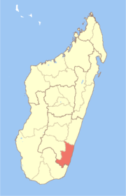
 Befotaka Location in Madagascar | |
| Coordinates: 23°49′30″S 46°58′44″E / 23.82500°S 46.97889°E | |
| Country |
|
| Region | Atsimo-Atsinanana |
| District | Befotaka Sud District |
| Elevation | 779 m (2,556 ft) |
| Time zone | EAT (UTC3) |
| Postal code | 307 |
Befotaka is a town in Atsimo-Atsinanana Region in south-eastern Madagascar. It is situated near the Itomampy river.
From the coast and Vangaindrano it can be reached by the unpaved, secondary road T18 of 94 km in very bad state of conservation to Nosifeno (formerly: Midongy Sud), to continue on another secondary road of 42 km to Befotaka.
Nature
It is the gateway to the Midongy du sud National Park (also called: Midongy-Betroka National Park) that is found in a distance of 34 km.[1]
Administration
To the commune of Befotaka also belong the following villages:
- Ambohimasoa
- Ambondr
- Andasy
- Andioteny
- Andranovory, Befotaka
- Andria, Befotaka
- Ankazovelo, Befotaka
- Bekofafa
- Belenalena
- Morarano
- Soabonaka
- Soavariana
- Soarano
References
This article is issued from Wikipedia - version of the 12/29/2013. The text is available under the Creative Commons Attribution/Share Alike but additional terms may apply for the media files.