Barton Turf
| Barton Turf | |
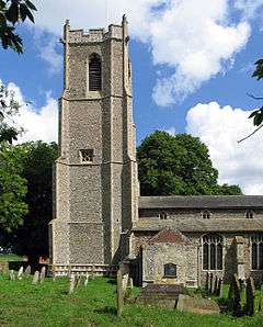 St Michael and All Angels parish church. |
|
 Barton Turf |
|
| Area | 10.86 km2 (4.19 sq mi) |
|---|---|
| Population | 467 (2011) |
| – density | 44/km² |
| OS grid reference | TG353224 |
| – London | 132 miles (212 km) |
| Civil parish | Barton Turf |
| District | North Norfolk |
| Shire county | Norfolk |
| Region | East |
| Country | England |
| Sovereign state | United Kingdom |
| Post town | NORWICH |
| Postcode district | NR12 |
| Dialling code | 01263 |
| Police | Norfolk |
| Fire | Norfolk |
| Ambulance | East of England |
| EU Parliament | East of England |
| UK Parliament | North Norfolk |
Coordinates: 52°44′53″N 1°29′06″E / 52.74796°N 1.48493°E
Barton Turf is a village and civil parish in the English county of Norfolk. The village is situated some 20 km north-east of the city of Norwich, on the northwestern edge of Barton Broad, the second largest broad of the Norfolk Broads[1] For the purposes of local government, the parish falls within the district of North Norfolk.[2]
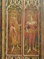
The civil parish, which includes the whole of Barton Broad and the smaller village of Irstead at its southern end, has an area of 10.86 km2. In the 2001 census it had a population of 480 in 181 households, the population decreasing to 467 at the 2011 Census.[3] Barton Turf's St Michael and All Angels Church, Barton Turf, situated a mile from the village, is noted its very rare medieval painted rood screen.
Gallery
-
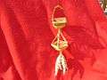
Barton Turf has given its name to a traditional Corn dolly which consists of two vertical baskets.
-
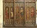
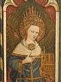
Some paintings from the 15th Century Rood Screen in St. Michael and All Angels church, Barton Turf
-
Thrones from the 15th Century Rood Screen in St. Michael and All Angels church, Barton Turf
-
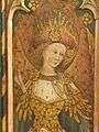
Cherubim from the 15th Century Rood Screen in St. Michael and All Angels church, Barton Turf
-
Iconoclastic damage from the Reformation, St. Michael and All Angels church, Barton Turf
References
- ↑ Ordnance Survey (2005). OS Explorer Map OL40 - The Broads. ISBN 0-319-23769-9.
- ↑ Office for National Statistics & Norfolk County Council (2001). Census population and household counts for unparished urban areas and all parishes. Retrieved December 2, 2005.
- ↑ "Civil Population 2011". Retrieved 2 September 2015.
External links
| Wikimedia Commons has media related to Barton Turf. |
- High resolution images of the Barton Turf Rood Screen
- Information from Genuki Norfolk on Barton Turf
- Barton [Turf] in the Domesday Book