Ban Dung District
| Ban Dung บ้านดุง | |
|---|---|
| Amphoe | |
|
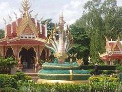
Shrine in Sri Sut Tho | |
 Amphoe location in Udon Thani Province | |
| Coordinates: 17°42′4″N 103°15′35″E / 17.70111°N 103.25972°ECoordinates: 17°42′4″N 103°15′35″E / 17.70111°N 103.25972°E | |
| Country |
|
| Province | Udon Thani |
| Tambon | 13 |
| Muban | 159 |
| Amphoe established | 1959 |
| Government | |
| • District head officer | Paitoon Chitsuttipon (นายไพฑูรย์ จิตต์สุทธิผล ) |
| Area | |
| • Total | 923.768 km2 (356.669 sq mi) |
| Population (2013) | |
| • Total | 124,812 |
| • Density | 133.2/km2 (345/sq mi) |
| Time zone | ICT (UTC+7) |
| Postal code | 41190 |
| Geocode | 4111 |
Ban Dung (Thai: บ้านดุง) is a district (amphoe) in northeastern Udon Thani Province, northeastern Thailand.
Geography
Neighboring districts are (from the south clockwise) Thung Fon, Phibun Rak, Phen, and Sang Khom of Udon Thani Province, Phon Phisai and Fao Rai of Nong Khai Province, and Ban Muang, Charoen Sin, and Sawang Daen Din of Sakon Nakhon Province.
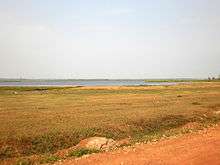
North of Ban Dung are marshlands and open water called Nong Pla Tao.
The major river is the Songkhram, which marks the boundary of the district to the east.
History
The minor district (king amphoe) Ban Dung was established on 16 May 1959, when three sub-districts were split off from Nong Han district.[1] It was upgraded to a full district on 16 July 1963.[2]
Administration
Central administration
The district Ban Dung is divided into 13 sub-districts (tambon), which are further divided into 159 administrative villages (muban).[3]
| No. | Name | Thai | Villages | Pop.[4] |
|---|---|---|---|---|
| 1. | Si Suttho | ศรีสุทโธ | 12 | 14,571 |
| 2. | Ban Dung | บ้านดุง | 18 | 13,756 |
| 3. | Dong Yen | ดงเย็น | 8 | 6,720 |
| 4. | Phon Sung | โพนสูง | 17 | 11,160 |
| 5. | Om Ko | อ้อมกอ | 10 | 8,568 |
| 6. | Ban Chan | บ้านจันทน์ | 18 | 14,277 |
| 7. | Ban Chai | บ้านชัย | 9 | 8,615 |
| 8. | Na Mai | นาไหม | 13 | 10,232 |
| 9. | Thon Na Lap | ถ่อนนาลับ | 8 | 5,272 |
| 10. | Wang Thong | วังทอง | 9 | 6,252 |
| 11. | Ban Muang | บ้านม่วง | 14 | 8,584 |
| 12. | Ban Tat | บ้านตาด | 10 | 6,987 |
| 13. | Na Kham | นาคำ | 13 | 9,818 |
Local administration
There is one town (Thesaban Mueang) in the district:
- Ban Dung (Thai: เทศบาลเมืองบ้านดุง) consisting of the complete sub-district Si Suttho and parts of the sub-district Ban Dung. The town is subdivided into 34 communities (chumchon).
There are 12 sub-district administrative organizations (SAO) in the district:
- Ban Dung (Thai: องค์การบริหารส่วนตำบลบ้านดุง) consisting of parts of the sub-district Ban Dung.
- Dong Yen (Thai: องค์การบริหารส่วนตำบลดงเย็น) consisting of the complete sub-district Dong Yen.
- Phon Sung (Thai: องค์การบริหารส่วนตำบลโพนสูง) consisting of the complete sub-district Phon Sung.
- Om Ko (Thai: องค์การบริหารส่วนตำบลอ้อมกอ) consisting of the complete sub-district Om Ko.
- Ban Chan (Thai: องค์การบริหารส่วนตำบลบ้านจันทน์) consisting of the complete sub-district Ban Chan.
- Ban Chai (Thai: องค์การบริหารส่วนตำบลบ้านชัย) consisting of the complete sub-district Ban Chai.
- Na Mai (Thai: องค์การบริหารส่วนตำบลนาไหม) consisting of the complete sub-district Na Mai.
- Thon Na Lap (Thai: องค์การบริหารส่วนตำบลถ่อนนาลับ) consisting of the complete sub-district Thon Na Lap.
- Wang Thong (Thai: องค์การบริหารส่วนตำบลวังทอง) consisting of the complete sub-district Wang Thong.
- Ban Muang (Thai: องค์การบริหารส่วนตำบลบ้านม่วง) consisting of the complete sub-district Ban Muang.
- Ban Tat (Thai: องค์การบริหารส่วนตำบลบ้านตาด) consisting of the complete sub-district Ban Tat.
- Na Kham (Thai: องค์การบริหารส่วนตำบลนาคำ) consisting of the complete sub-district Na Kham.
Central government services
- Crown Prince Hospital Ban Dung
- Has 114 beds and 10 physicians.
- Ban Dung Police
- Has 14 officers and 79 non-commissioned officers
- Dong Yen Police
- Has 10 officers and 25 non-commissioned officers
- Forest Protection Unit
- Ban Dung District Revenue
- Ban Dung Arboretum
State enterprises and organizations
- Provincial Electricity Authority (PEA)
- Water Supply Authority
- Bank for Agriculture and Agricultural Co-operatives (BAAC)
- Government Savings Bank
Education
- Five secondary schools
- 71 elementary schools
- Six private schools
- One technical school
Religion
As in the rest of Thailand, the population is almost exclusively Theravada Buddhist, although this is combined with elements of animism and in rural areas there are pockets of Christianity. Overall within the district 91.13 percent are Buddhist with Catholics representing 8.87 percent. Within the amphoe there are 104 Buddhist temples and seven Catholic churches in the villages of Phon Sung, Ban Thung Kwang Patana, Ban Non Sombun, Ban Pak Dong, Sri Wattana, and Sri Sut Tho and one Protestant church, also in Sri Sut Tho.
Media
In common with may other districts Ban Dung has its own local radio station which broadcasts on FM 103 MHz. All broadcasts are in Thai.
Economy
The average income per year in Ban Dung was 42,023 baht per person in 2011 with the majority of people being farmers. However, there is an increasing number of people employed in the retail and building trades as the town continues to increase in size with a steady influx of people moving into Ban Dung including a significant number of expats and their spouses.
Farming
The major crop grown is rice with 259,066 rai being cultivated by 13,708 people out of a total farming area of 327,480 rai. There was also 15,667 rai of rubber under cultivation, 550 rai of palm oil, and 1,445 rai used for rock salt extraction. Other crops included maize, cassava, eucalyptus, sugar cane and various fruit and vegetables. Other farming activities included the rearing of buffalo, cattle, pigs, and chickens with a small number of people raising fish in lakes or ponds.
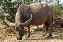
Water buffalo are a regular feature being walked to and from the fields at dawn and dusk. Although rarely used nowadays for working the land, they are considered an important status symbol.
Retail
The retail sector plays a large part in the local economy and in addition to its two large markets Ban Dung also has two Tesco Lotuss, two 7-Elevens, nine gold shops, seven motorcycle retail outlets, two car showrooms, 11 karaoke bars, five hotels, and over twenty resort hotels. It also has many other shops ranging from Internet cafes and farang bars to agricultural supplies.
OTOP
There are various products produced in the tambons under the OTOP (One Tambon One Product) scheme. These include textile dyeing, silk weaving, knitwear products, woven reed mats, mattress and pillows, woven blankets, shampoo, and local herbs.
Salt production
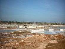
The salt making area around Ban Dung has produced salt for industrial purposes for more than 25 years. The production method used as in many other places in northeast Thailand is called solution mining. The mining is done by local co-operative groups.
Refined salt for domestic use is made by evaporating salt water in large open vats using ovens with rice husks used as the fuel source. This method produces very clean, fine grained salt in which the impurities are removed during cooking. Traditionally, the stove used in salt making was wood-fueled. Wood became more expensive, prompting a shift to rice hull stoves. The abundance of rice hulls has made it economically feasible to reprocess the salt and is a renewable source of fuel. The residue, rice hull ash, (RHA) is then sold back to farmers for use as fertilizer.
Places of interest
- Wat Kham Chanot: Approximately 10 km from Ban Dung, Wat Kham Chanot is said to be an entrance to the water world, a legendary place where the Naga, a mythical large snake often suggested to have seven heads, is supposed to live. Covering an area of over 20 rai of land, it is nothing but an islet surrounded by water with dense palm trees called "chanot".
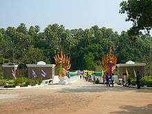
- The City Pillar Shrine in tambon Sri Sut Tho: A symbol of the amphoe.
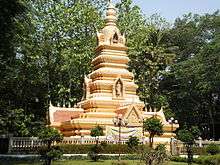
- Pagoda and temple at Ban Lao Luang: The pagoda and temple host relics of Buddha brought from India on 1 May 2000.
- Pagoda at Ban Dong Sawan: The bones and possessions of Ajahn Luang Pu reside here and is a sacred place for many Buddhists.
- Voice of America: The Voice of America headquarters for Southeast Asia is three kilometres out of Ban Dung on Highway 2022. Many 500 kW shortwave transmitters are installed here. Call sign: Udon Thani.
Transportation
The town is adjacent to the intersection of Highway 2022 and Highway 2096.
Buses
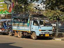
Essential local services are provided by songthaew truck and pickup truck buses, while regional and long distance destinations are served by regular buses from Udon Thani.
There are two main public buses. Both start at the central bus station in Udon Thani. One bus route goes via Highway 22 and then turns left at Nong Mek along Highway 2096 to Ban Dung (Kham Takla bus route). The other bus route goes via Highway 2 before turning right at Ban Na Kha along Highway 2256 to the Sum Sao intersection and then along Highway 2022 to Ban Dung (Bueng Kan Bus route). Both run at regular intervals.
Long-distance VIP buses operate from opposite the police station and run nightly to Bangkok. There are also direct night buses to and from Pattaya.
References
- ↑ ประกาศกระทรวงมหาดไทย เรื่อง ยกฐานะตำบลขึ้นเป็นกิ่งอำเภอ (PDF). Royal Gazette (in Thai). 76 (53 ง): 1368–1369. 1959-05-19.
- ↑ พระราชกฤษฎีกาตั้งอำเภอบ่อพลอย อำเภอไทรโยค อำเภอหนองเรือ อำเภอหนองสองห้อง อำเภอประทาย อำเภอห้วยแถลง อำเภอละหานทราย อำเภอกุยบุรี อำเภอตาพระยา อำเภอหนองไผ่ อำเภอนาเชือก อำเภอวัดเพลง อำเภอพนัสนิคม อำเภอภูกระดึง อำเภอปรางค์กู่ อำเภอท่าช้าง อำเภอบ้านด่านลานหอย อำเภอบ้านดง อำเภอสว่างอารมณ์ และอำเภอกุดชุม พ.ศ. ๒๕๐๖ (PDF). Royal Gazette (in Thai). 80 (72 ก): 362. 1963-07-16.
- ↑ Bandung Administrative website
- ↑ "Population statistics 2013" (in Thai). Department of Provincial Administration. Retrieved 2014-12-18.
External links
| Wikimedia Commons has media related to Ban Dung District. |