Aldwark, Derbyshire
| Aldwark | |
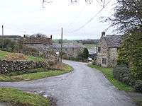 The small village in 2006 |
|
 Aldwark parish highlighted within Derbyshire |
|
| Population | 189 (Including Ballidon and Grangemill 2011) |
|---|---|
| OS grid reference | SK228573 |
| District | Derbyshire Dales |
| Shire county | Derbyshire |
| Region | East Midlands |
| Country | England |
| Sovereign state | United Kingdom |
| Post town | Matlock |
| Postcode district | DE4 |
| Police | Derbyshire |
| Fire | Derbyshire |
| Ambulance | East Midlands |
| EU Parliament | East Midlands |
|
|
Aldwark (Old English The Old Fortification [1]) is a small upland village and parish in the Derbyshire Dales district of Derbyshire, England, lying about eight miles (13 kilometres) WSW of Matlock by road or five miles (eight kilometres) as the crow flies. Close by are a number of Neolithic burial sites, the most notable being tree-crowned Minninglow, visible for many miles around.
The village is just within the boundaries of the Peak District National Park. The 2001 census recorded a population of just 39 for the parish; over 100 years ago, the township's inhabitants numbered 40.[2] At the 2011 Census the population had increased to 180.[3] In the eighteenth century Aldwark was probably busier, being a stopping point on the stagecoach route from Buxton to Derby.
References
- ↑ "Aldwark". Key to English Place-names. English Place Name Society at the University of Nottingham. Retrieved 19 August 2013.
- ↑ The Comprehensive Gazetteer of England and Wales, 1894-5
- ↑ "Civil Parish population 2011". Neighbourhood Statistics. Office for National Statistics. Retrieved 19 March 2016.
External links
![]() Media related to Aldwark, Derbyshire at Wikimedia Commons
Coordinates: 53°06′47″N 1°39′36″E / 53.11312°N 1.65987°E
Media related to Aldwark, Derbyshire at Wikimedia Commons
Coordinates: 53°06′47″N 1°39′36″E / 53.11312°N 1.65987°E