Ala-Buka District
| Ala-Buka | |
|---|---|
| Raion | |
 | |
| Country | Kyrgyzstan |
| Region | Jalal-Abad Region |
| Area | |
| • Total | 2,976 km2 (1,149 sq mi) |
| Population (2009 census) | |
| • Total | 81,500 |
| • Density | 27/km2 (71/sq mi) |
| Time zone | GMT +5 (UTC+5) |
Ala-Buka is a raion (district) of Jalal-Abad Region in western Kyrgyzstan. The capital lies at Ala-Buka.[1]
Populated areas
As of 2009, Ala-Buka District comprised 41 villages in 8 rural communities (aiyl okmotus). Its population, according to the Population and Housing Census of 2009 amounted to 81,488 (enumerated de facto population).[2] The populated areas in the Ala-Buka District are:[3]
- Ak-Korgon aiyl okmotu (Ak-Korgon, Safedbulan, Padek, and Bayastan)
- Ak-Tam aiyl okmotu (Ak-Tam, Japa-Saldy, and Kyzyl-Ata)
- Ala-Buka aiyl okmotu (Ala-Buka, Dostuk, Sapalak, and Sary-Talaa)
- Kek-Serek aiyl okmotu (Tengi, Ak-Taylak, Birlishken, Koshbolot, Sara-Kel, and Teleke)
- Oruktu aiyl okmotu (Oruktu, Kenkol, Orto-Tokoy, Oruktu Say, and Cholok Tuma )
- Pervomay aiyl okmotu (Ayry-Tam, Ak-Bashat, Alma-Bel', Jany-Shaar, Kara-Unkyur, Ajek, and Sovet-Say)
- Torogeldi Baltagul aiyl okmotu (Yzar, Baymak, Kashkalak, Kelte, Kosh-Almurut, and Kosh-Terek)
- Kek-Tash aiyl okmotu (Bulak-Bashi, Jalgyz-Oryuk, Kek-Tash, Kulpek-Say, Orto-Suu, and Chong-Say)
References
- ↑ Enrin.grida.no
- ↑ Population and Housing Census 2009. Book 3 (in tables). Regions of Kyrgyzstan: Jalal-Abad Region (Перепись населения и жилищного фонда Кыргызской Республики 2009. Книга 3 (в таблицах). Регионы Кыргызстана: Джалал-Абадская область (PDF), Bishkek: National Committee on Statistics, 2010, archived from the original (PDF) on August 10, 2011
- ↑ List of rural communities of Kyrgyzstan
Capital: Bishkek (also four raions: Lenin, Oktyabr, Pervomay, Sverdlov) | ||
| Batken Region | 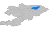 | |
| Chuy Region | ||
| Issyk Kul Region | ||
| Jalal-Abad Region | ||
| Naryn Region | ||
| Osh Region | ||
| Talas Region | ||
Coordinates: 41°24′29″N 71°27′47″E / 41.40806°N 71.46306°E
This article is issued from Wikipedia - version of the 7/1/2016. The text is available under the Creative Commons Attribution/Share Alike but additional terms may apply for the media files.